File:Earth from Orbit- Monumental U S Storm Brings Severe Winter Weather Coast to Coast (52723672863).png
Size of this preview: 800 × 450 pixels. Other resolutions: 320 × 180 pixels | 640 × 360 pixels | 1,024 × 576 pixels | 1,280 × 720 pixels | 1,920 × 1,080 pixels.
Original file (1,920 × 1,080 pixels, file size: 3.18 MB, MIME type: image/png)
Captions
Captions
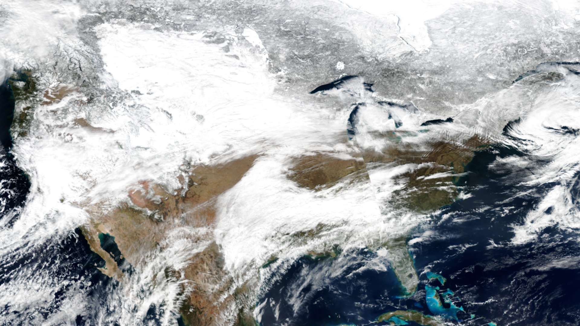
Since mid-February 2023, winter weather has impacted the continental U.S. from California to Maine.
Summary
edit.png&action=edit§ion=1)
| Description |
English: Since mid-February 2023, winter weather has impacted the continental U.S. from California to Maine. In Southern California, the storm brought blizzard conditions to the San Bernardino and San Gabriel mountains as well as heavy rainfall to lower elevations. As the storm system continued eastward, snow and driving winds caused road closures and drifting snow across the Plains. Further south in Kansas and Oklahoma, tornadoes downed power lines, damaged property, and caused injuries. Additional tornadoes were reported in central and northeastern Illinois. The storm also brought heavy snow to the Northeast. NOAA satellites provided complementary measurements for a complete picture of this monumental storm and played a crucial role in tracking the storms across the U.S., alerting those in harm’s way.
www.nesdis.noaa.gov/news/monumental-us-storm-brings-sever... |
| Date | Taken on 3 March 2023, 08:32:48 |
| Source | Earth from Orbit: Monumental U.S. Storm Brings Severe Winter Weather Coast to Coast |
| Author | NOAASatellites |
| Flickr set | Earth from Orbit |
| Flickr tags | satellites; satelliteimagery; noaa; noaasatellites; jpss; earthfromorbit |
Licensing
edit.png&action=edit§ion=2)
This image is in the public domain because it contains materials that originally came from the U.S. National Oceanic and Atmospheric Administration, taken or made as part of an employee's official duties.
|
| This image was originally posted to Flickr by NOAASatellites at https://flickr.com/photos/125201706@N06/52723672863. It was reviewed on 19 February 2024 by FlickreviewR 2 and was confirmed to be licensed under the terms of the Public Domain Mark. |
File history
Click on a date/time to view the file as it appeared at that time.
| Date/Time | Thumbnail | Dimensions | User | Comment | |
|---|---|---|---|---|---|
| current | 09:42, 19 February 2024 | | 1,920 × 1,080 (3.18 MB) | OptimusPrimeBot (talk | contribs) | #Spacemedia - Upload of https://live.staticflickr.com/65535/52723672863_a0ff04611d_o.png via Commons:Spacemedia |
You cannot overwrite this file.
File usage on Commons
There are no pages that use this file.
.png&oldid=862941861)