File:Earth from Space- Bentiu, South Sudan ESA25136828.jpg

Original file (7,495 × 4,216 pixels, file size: 6.64 MB, MIME type: image/jpeg)
Captions
Captions
Summary
edit| Description |
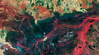
English: The landscape around the city of Bentiu in South Sudan is featured in this Copernicus Sentinel-2 image. Zoom in to explore this image at its full 10 m resolution or click on the circles to learn more. The majority of the people in South Sudan live in rural areas and rely on farming, fishing or herding for food and income. The country has always experienced a degree of seasonal flooding, which normally recedes in the dry season. However, four consecutive years of incessant flooding have submerged villages, farmlands and roads. In 2023, flood waters reached almost 2 metres in some places. This false-colour image, captured in January 2023, clearly shows the extent of the flooded areas around Bentiu. Information from the mission’s near-infrared channel was used to process this image so water bodies appear in dark blue or black. Sediment in the waters is bright blue, while the vibrant shades of red, mainly bordering rivers, denote vegetation. The yellowish area in the centre of the image is the city of Bentiu. It stands out like an island surrounded by floods. Bentiu lies on the southern bank of the Bahr el-Ghazal River, which separates the city from the town of Rubkona on the opposite bank. Zooming in, the El Salaam Bridge can be seen spanning the river and connecting the two cities. The square structure just north of Rubkona is the Bentiu IDP refugee camp, where many people found shelter after losing their homes in the floods. These dry lands and some roads, visible as light green straight lines, now lie below the waterline, hemmed in by dikes that have been built to protect them from inundation. From Bentiu, the Bahr el-Ghazal River meanders through the inundated floodplain in a northeasterly direction. It can be traced in black in the right of the image flowing through Lake No into the White Nile. Fed by the White Nile, the large, swampy area running from the centre of the image to the bottom right is the Sudd. It is a network of channels, lakes and swamps and one of Africa’s largest floodplains, providing watering and feeding grounds for many endemic mammals and birds, as well as for large populations of migratory species. |
| Date | 13 October 2023 (upload date) |
| Source | Earth from Space: Bentiu, South Sudan |
| Author | European Space Agency |
| Other versions |
|
| Activity | Observing the Earth |
| Mission | Sentinel-2 |
| Set | Earth from Space image collection |
| System | Copernicus |

Licensing
edit

|
This image contains data from a satellite in the Copernicus Programme, such as Sentinel-1, Sentinel-2 or Sentinel-3. Attribution is required when using this image.
Attribution: Contains modified Copernicus Sentinel data 2023
The use of Copernicus Sentinel Data is regulated under EU law (Commission Delegated Regulation (EU) No 1159/2013 and Regulation (EU) No 377/2014). Relevant excerpts:
Free access shall be given to GMES dedicated data [...] made available through GMES dissemination platforms [...].
Access to GMES dedicated data [...] shall be given for the purpose of the following use in so far as it is lawful:
GMES dedicated data [...] may be used worldwide without limitations in time.
GMES dedicated data and GMES service information are provided to users without any express or implied warranty, including as regards quality and suitability for any purpose. |
This media was created by the European Space Agency (ESA).
Where expressly so stated, images or videos are covered by the Creative Commons Attribution-ShareAlike 3.0 IGO (CC BY-SA 3.0 IGO) licence, ESA being an Intergovernmental Organisation (IGO), as defined by the CC BY-SA 3.0 IGO licence. The user is allowed under the terms and conditions of the CC BY-SA 3.0 IGO license to Reproduce, Distribute and Publicly Perform the ESA images and videos released under CC BY-SA 3.0 IGO licence and the Adaptations thereof, without further explicit permission being necessary, for as long as the user complies with the conditions and restrictions set forth in the CC BY-SA 3.0 IGO licence, these including that:
See the ESA Creative Commons copyright notice for complete information, and this article for additional details.
|
 | |
This file is licensed under the Creative Commons Attribution-ShareAlike 3.0 IGO license. Attribution: ESA, CC BY-SA IGO 3.0
| ||
File history
Click on a date/time to view the file as it appeared at that time.
| Date/Time | Thumbnail | Dimensions | User | Comment | |
|---|---|---|---|---|---|
| current | 11:40, 29 October 2023 | | 7,495 × 4,216 (6.64 MB) | OptimusPrimeBot (talk | contribs) | #Spacemedia - Upload of https://www.esa.int/var/esa/storage/images/esa_multimedia/images/2023/10/earth_from_space_bentiu_south_sudan/25136818-1-eng-GB/Earth_from_Space_Bentiu_South_Sudan.jpg via Commons:Spacemedia |
You cannot overwrite this file.
File usage on Commons
The following page uses this file: