File:Earth from Space- Seychelles ESA496685.png

Original file (3,381 × 2,966 pixels, file size: 8.02 MB, MIME type: image/png)
Captions
Captions
Summary
edit| Description |
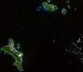
English: The Copernicus Sentinel-2 mission takes us over part of the Seychelles, an island republic in the western Indian Ocean. Zoom in to explore this image at its full 10 m resolution or click on the circles to learn more. Positioned about 1600 km east of Kenya and about 1100 km northeast of Madagascar, the Seychelles archipelago comprises around 115 small islands – spread across 90 000 sq km of ocean – with only eight being inhabited by humans. Some of these islands are visible in the image. The turquoise hues along the shores depict clear, shallow waters dotted by coral reefs, which contrast with the darker waters of the deep Indian Ocean. One of the world’s smallest countries, the archipelago consists of two main island groups: the central, mountainous, granitic islands, and the outer, flat, coralline islands. The two largest islands of the archipelago are featured in this image: Mahé (bottom left) and Praslin (top right). Both belong to the granitic island group. Mahé is home to the capital Victoria, clear to see on the northeastern coast. Victoria serves as the only port in the Seychelles, capable of accommodating several ships at one time. The white dots in the water show vessels around the port. The Seychelles International Airport is visible to the west. As evident from the image, lush vegetation covers much of the island, mainly protected by national parks. The Morne Seychellois National Park is the largest, extending approximately 3000 hectares, encompassing over 20% of Mahé’s land. The park features mangroves, tropical jungles and mountains, including the 900 m-high Morne Seychellois – the highest peak in the whole archipelago. Many low-lying islands, especially the coralline islands, and most coastal areas are at risk of disappearing or becoming uninhabitable due to sea-level rise, driven by the climate crisis. Earth-observing satellites are used to monitor global and regional sea-level change and coastal erosion and to assess vulnerability. These observations support adaptation and resilience strategies to mitigate the growing threat posed by sea-level rise. |
| Date | 26 April 2024 (upload date) |
| Source | Earth from Space: Seychelles |
| Author | European Space Agency |
| Other versions |
|
| Activity | Observing the Earth |
| Mission | Sentinel-2 |
| Set | Earth from Space image collection |
| System | Copernicus |
Licensing
edit

|
This image contains data from a satellite in the Copernicus Programme, such as Sentinel-1, Sentinel-2 or Sentinel-3. Attribution is required when using this image.
Attribution: Contains modified Copernicus Sentinel data 2021
The use of Copernicus Sentinel Data is regulated under EU law (Commission Delegated Regulation (EU) No 1159/2013 and Regulation (EU) No 377/2014). Relevant excerpts:
Free access shall be given to GMES dedicated data [...] made available through GMES dissemination platforms [...].
Access to GMES dedicated data [...] shall be given for the purpose of the following use in so far as it is lawful:
GMES dedicated data [...] may be used worldwide without limitations in time.
GMES dedicated data and GMES service information are provided to users without any express or implied warranty, including as regards quality and suitability for any purpose. |
This media was created by the European Space Agency (ESA).
Where expressly so stated, images or videos are covered by the Creative Commons Attribution-ShareAlike 3.0 IGO (CC BY-SA 3.0 IGO) licence, ESA being an Intergovernmental Organisation (IGO), as defined by the CC BY-SA 3.0 IGO licence. The user is allowed under the terms and conditions of the CC BY-SA 3.0 IGO license to Reproduce, Distribute and Publicly Perform the ESA images and videos released under CC BY-SA 3.0 IGO licence and the Adaptations thereof, without further explicit permission being necessary, for as long as the user complies with the conditions and restrictions set forth in the CC BY-SA 3.0 IGO licence, these including that:
See the ESA Creative Commons copyright notice for complete information, and this article for additional details.
|
 | |
This file is licensed under the Creative Commons Attribution-ShareAlike 3.0 IGO license. Attribution: ESA, CC BY-SA IGO 3.0
| ||
File history
Click on a date/time to view the file as it appeared at that time.
| Date/Time | Thumbnail | Dimensions | User | Comment | |
|---|---|---|---|---|---|
| current | 06:01, 27 April 2024 | | 3,381 × 2,966 (8.02 MB) | OptimusPrimeBot (talk | contribs) | #Spacemedia - Upload of https://www.esa.int/var/esa/storage/images/esa_multimedia/images/2024/04/earth_from_space_seychelles/26051311-1-eng-GB/Earth_from_Space_Seychelles.png via Commons:Spacemedia |
You cannot overwrite this file.
File usage on Commons
The following page uses this file: