File:Earthquake 2016 Oklahoma USGS en.jpg
Size of this preview: 640 × 599 pixels. Other resolutions: 256 × 240 pixels | 820 × 768 pixels | 1,093 × 1,024 pixels | 2,187 × 2,048 pixels | 3,736 × 3,499 pixels.
Original file (3,736 × 3,499 pixels, file size: 2.61 MB, MIME type: image/jpeg)
Captions
Captions
Add a one-line explanation of what this file represents
Summary edit
| Description |
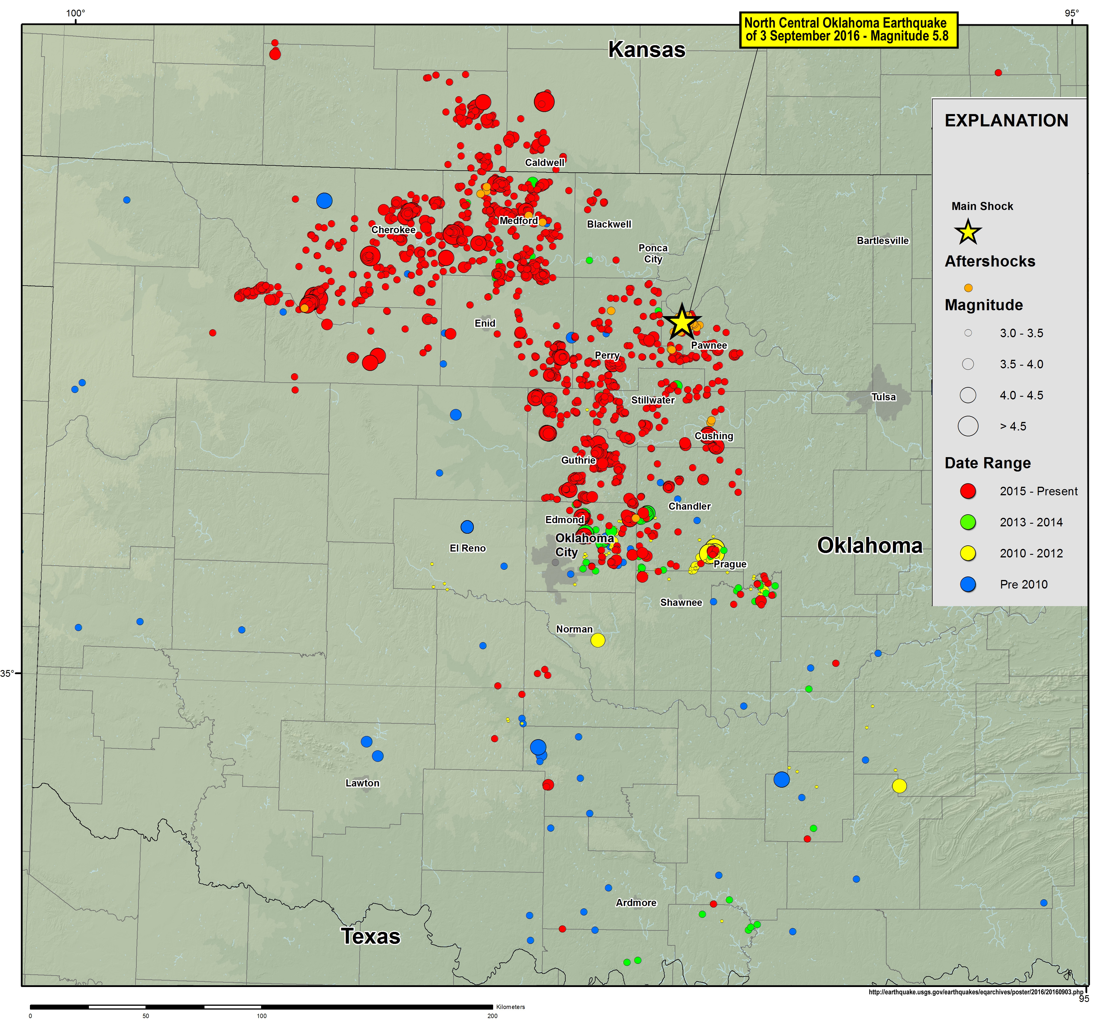
Français : Extrait d'une carte produite en 2016 par l'USGS relative au tremblement de terre du 3 septembre 2016, de magnitude 5.8 - situé à près de 15km au NW de la petite ville de Pawnee (2000 hbts environ) en Oklahoma.
The yellow star indicates the position of the epicenter (depth 5.4 km) from the earthquake, which is probably an earthquake induced by the shale gas (fracking and water reinjection). The map also shows a very rapid growth in land quakes observed in this region with chronologically blue dots, yellow and red (given that 2016 was not yet completed at the time of the completion of the map ; other earthquakes and perhaps replicas of this earthquake are expected by the USGS)
English: Extract from a map produced in 2016 by the USGS on the earthquake of September 3, 2016, magnitude 5.8 - located about 15 km NW of the town of Pawnee (2000 hbts approximately) in Oklahoma.
The yellow star indicates the position of the epicenter (depth 5.4 km) from this earthquake, which is probably an earthquake induced by the shale gas industry (because of fracking and water reinjection). The map also shows a very rapid growth in land quakes observed in this region with chronologically blue dots, yellow and red (given that this map in sept 2016 was not yet completed ; other earthquakes and perhaps replicas of this earthquake are expected by the USGS) |
| Date | |
| Source | Own work |
| Author | Lamiot |
This image is in the public domain in the United States because it only contains materials that originally came from the United States Geological Survey, an agency of the United States Department of the Interior. For more information, see the official USGS copyright policy.
|
source: https://earthquake.usgs.gov/earthquakes/eqarchives/poster/2016/20160903.php
Licensing edit
I, the copyright holder of this work, hereby publish it under the following license:
This file is licensed under the Creative Commons Attribution-Share Alike 4.0 International license.
- You are free:
- to share – to copy, distribute and transmit the work
- to remix – to adapt the work
- Under the following conditions:
- attribution – You must give appropriate credit, provide a link to the license, and indicate if changes were made. You may do so in any reasonable manner, but not in any way that suggests the licensor endorses you or your use.
- share alike – If you remix, transform, or build upon the material, you must distribute your contributions under the same or compatible license as the original.
File history
Click on a date/time to view the file as it appeared at that time.
| Date/Time | Thumbnail | Dimensions | User | Comment | |
|---|---|---|---|---|---|
| current | 09:08, 17 September 2016 | | 3,736 × 3,499 (2.61 MB) | Lamiot (talk | contribs) | User created page with UploadWizard |
You cannot overwrite this file.
File usage on Commons
There are no pages that use this file.
File usage on other wikis
The following other wikis use this file:
- Usage on de.wikipedia.org