File:Africa railway map gauge.jpg
(Redirected from File:East Africa Railway Master Plan.jpg)

Size of this preview: 625 × 600 pixels. Other resolutions: 250 × 240 pixels | 500 × 480 pixels | 800 × 768 pixels | 1,067 × 1,024 pixels | 1,472 × 1,413 pixels.
Original file (1,472 × 1,413 pixels, file size: 220 KB, MIME type: image/jpeg)
Captions
Captions
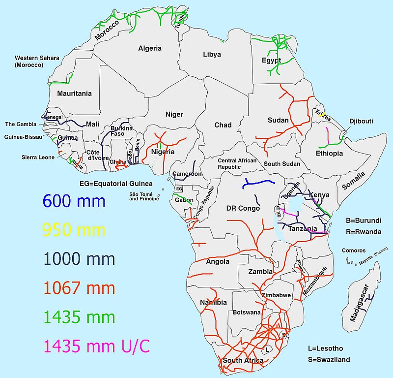
Map of Africa showing railway gauges including those under construction.
Summary
edit| Description |
English: Schematic map of African railways by gauge |
| Date | |
| Source | Own work |
| Author | Bucsky |
| Other versions | East Africa Railway Master Plan |

|
This rail transport map image could be re-created using vector graphics as an SVG file. This has several advantages; see Commons:Media for cleanup for more information. If an SVG form of this image is available, please upload it and afterwards replace this template with
{{vector version available|new image name}}.
It is recommended to name the SVG file “Africa railway map gauge.svg”—then the template Vector version available (or Vva) does not need the new image name parameter. |

Licensing
edit
I, the copyright holder of this work, hereby publish it under the following license:
This file is licensed under the Creative Commons Attribution-Share Alike 4.0 International license.
- You are free:
- to share – to copy, distribute and transmit the work
- to remix – to adapt the work
- Under the following conditions:
- attribution – You must give appropriate credit, provide a link to the license, and indicate if changes were made. You may do so in any reasonable manner, but not in any way that suggests the licensor endorses you or your use.
- share alike – If you remix, transform, or build upon the material, you must distribute your contributions under the same or compatible license as the original.
File history
Click on a date/time to view the file as it appeared at that time.
| Date/Time | Thumbnail | Dimensions | User | Comment | |
|---|---|---|---|---|---|
| current | 20:14, 27 January 2018 | | 1,472 × 1,413 (220 KB) | Metrancya (talk | contribs) | The file quality isn't the best - but made a few enhancements (Sudan, Kenya, Tanzania, Rwanda, Libya, Eritrea) plus formal things |
| 08:25, 27 December 2017 |  | 1,800 × 1,428 (556 KB) | Bucsky (talk | contribs) | User created page with UploadWizard |
You cannot overwrite this file.
File usage on Commons
The following 6 pages use this file:
- Sahara Desert
- User:Chumwa/OgreBot/Potential transport maps/2018 January 21-31
- User:Chumwa/OgreBot/Public transport information/2018 January 21-31
- User:Chumwa/OgreBot/Transport Maps/2018 January 21-31
- User:Chumwa/OgreBot/Travel and communication maps/2018 January 21-31
- File:East Africa Railway Master Plan.jpg (file redirect)
File usage on other wikis
The following other wikis use this file:
- Usage on ar.wikipedia.org
- Usage on en.wikipedia.org
- Usage on fr.wikipedia.org
- Usage on ha.wikipedia.org
- Usage on ig.wikipedia.org
- Usage on ja.wikipedia.org
- Usage on ru.wikipedia.org
- Usage on ur.wikipedia.org
- Usage on www.wikidata.org