File:East Croydon station tram stop - geograph.org.uk - 853137.jpg
No higher resolution available.
East_Croydon_station_tram_stop_-_geograph.org.uk_-_853137.jpg (640 × 402 pixels, file size: 72 KB, MIME type: image/jpeg)
Captions
Captions
Add a one-line explanation of what this file represents
Summary
edit
| Description |
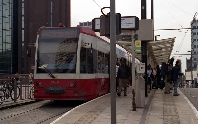
English: East Croydon station tram stop This track is used by cars going to the Town Centre, either round the loop, (as in this case), or through to Wimbledon (Route No 3 cars). The track on the right is normally used only for short-working cars, while off-camera far right is the track for the eastbound cars to Elmers End, Beckenham Junction, or New Addington. |
| Date | |
| Source | From geograph.org.uk |
| Author | Dr Neil Clifton |
| Attribution (required by the license) | Dr Neil Clifton / East Croydon station tram stop / |
| Camera location | | View this and other nearby images on: OpenStreetMap |
|---|
_heading:247.00&language=en)
| Object location | | View this and other nearby images on: OpenStreetMap |
|---|
_heading:247.00&language=en)
Licensing
edit

|
This image was taken from the Geograph project collection. See this photograph's page on the Geograph website for the photographer's contact details. The copyright on this image is owned by Dr Neil Clifton and is licensed for reuse under the Creative Commons Attribution-ShareAlike 2.0 license.
|
This file is licensed under the Creative Commons Attribution-Share Alike 2.0 Generic license.
Attribution: Dr Neil Clifton
- You are free:
- to share – to copy, distribute and transmit the work
- to remix – to adapt the work
- Under the following conditions:
- attribution – You must give appropriate credit, provide a link to the license, and indicate if changes were made. You may do so in any reasonable manner, but not in any way that suggests the licensor endorses you or your use.
- share alike – If you remix, transform, or build upon the material, you must distribute your contributions under the same or compatible license as the original.
File history
Click on a date/time to view the file as it appeared at that time.
| Date/Time | Thumbnail | Dimensions | User | Comment | |
|---|---|---|---|---|---|
| current | 02:06, 21 February 2011 | | 640 × 402 (72 KB) | GeographBot (talk | contribs) | == {{int:filedesc}} == {{Information |description={{en|1=East Croydon station tram stop This track is used by cars going to the Town Centre, either round the loop, (as in this case), or through to Wimbledon (Route No 3 cars). The track on the right is no |
You cannot overwrite this file.
File usage on Commons
There are no pages that use this file.