File:East Link map with stations.png

Size of this preview: 800 × 473 pixels. Other resolutions: 320 × 189 pixels | 640 × 379 pixels | 1,024 × 606 pixels | 1,280 × 757 pixels | 2,538 × 1,501 pixels.
Original file (2,538 × 1,501 pixels, file size: 1.59 MB, MIME type: image/png)
Captions
Captions
Add a one-line explanation of what this file represents
Summary edit
| Description |
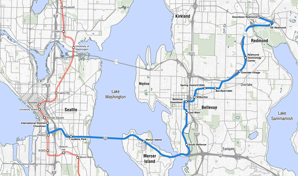
English: A map of the East Link Extension, an under construction Link light rail line that will connect Seattle to its eastern suburbs. |
| Date | |
| Source |
GIS data:
Highway shields:
|
| Author | SounderBruce |
Licensing edit
I, the copyright holder of this work, hereby publish it under the following license:
This file is licensed under the Creative Commons Attribution-Share Alike 4.0 International license.
- You are free:
- to share – to copy, distribute and transmit the work
- to remix – to adapt the work
- Under the following conditions:
- attribution – You must give appropriate credit, provide a link to the license, and indicate if changes were made. You may do so in any reasonable manner, but not in any way that suggests the licensor endorses you or your use.
- share alike – If you remix, transform, or build upon the material, you must distribute your contributions under the same or compatible license as the original.
File history
Click on a date/time to view the file as it appeared at that time.
| Date/Time | Thumbnail | Dimensions | User | Comment | |
|---|---|---|---|---|---|
| current | 02:37, 7 February 2018 | | 2,538 × 1,501 (1.59 MB) | SounderBruce (talk | contribs) | Less prominent location labels |
| 02:26, 29 January 2018 |  | 2,538 × 1,501 (1.58 MB) | SounderBruce (talk | contribs) | Adding missing labels for Westlake and Pioneer Square; adjusted SR 520 shield in Overlake | |
| 08:33, 28 January 2018 |  | 2,538 × 1,501 (1.58 MB) | SounderBruce (talk | contribs) | User created page with UploadWizard |
You cannot overwrite this file.
File usage on Commons
The following 10 pages use this file:
- User:Chumwa/OgreBot/Potential transport maps/2018 February 1-9
- User:Chumwa/OgreBot/Potential transport maps/2018 January 21-31
- User:Chumwa/OgreBot/Public transport information/2018 February 1-9
- User:Chumwa/OgreBot/Public transport information/2018 January 21-31
- User:Chumwa/OgreBot/Transport Maps/2018 February 1-9
- User:Chumwa/OgreBot/Transport Maps/2018 January 21-31
- User:Chumwa/OgreBot/Travel and communication maps/2018 February 1-9
- User:Chumwa/OgreBot/Travel and communication maps/2018 January 21-31
- User:SounderBruce
- Commons:Graphic Lab/Map workshop/Archive/2024
File usage on other wikis
The following other wikis use this file:
- Usage on de.wikipedia.org
- Usage on en.wikipedia.org