File:East of England map.svg

Size of this PNG preview of this SVG file: 789 × 599 pixels. Other resolutions: 316 × 240 pixels | 632 × 480 pixels | 1,011 × 768 pixels | 1,280 × 972 pixels | 2,560 × 1,944 pixels | 1,464 × 1,112 pixels.
Original file (SVG file, nominally 1,464 × 1,112 pixels, file size: 434 KB)
Captions
Captions
Add a one-line explanation of what this file represents
Summary edit
| Description |
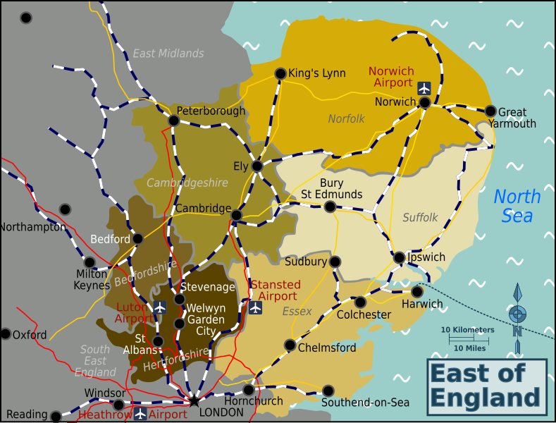
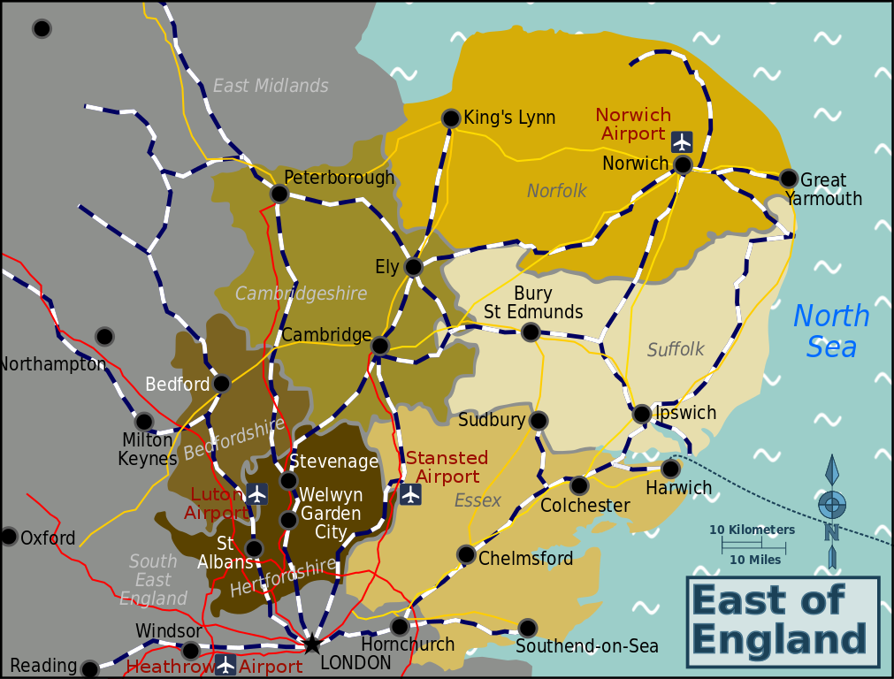
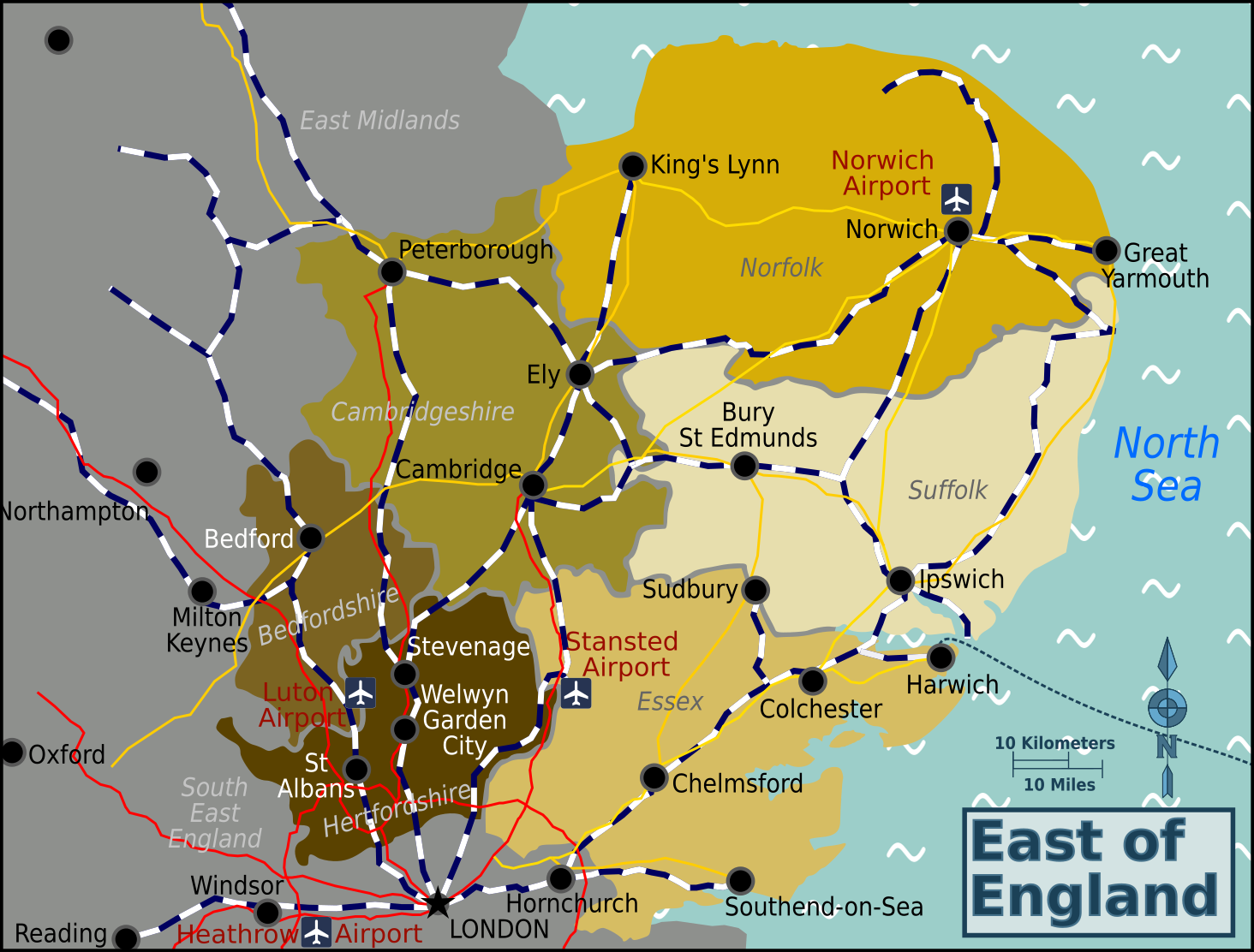
English: East of England. Map of the East of England showing sub-regions and transport, East of England |
| Date | |
| Source | :Image:East Anglia map.png and www.openstreetmap.org |
| Author | Travelpleb |
This W3C-unspecified vector image was created with Inkscape .
Licensing edit
This file is licensed under the Creative Commons Attribution-Share Alike 3.0 Unported license.
- You are free:
- to share – to copy, distribute and transmit the work
- to remix – to adapt the work
- Under the following conditions:
- attribution – You must give appropriate credit, provide a link to the license, and indicate if changes were made. You may do so in any reasonable manner, but not in any way that suggests the licensor endorses you or your use.
- share alike – If you remix, transform, or build upon the material, you must distribute your contributions under the same or compatible license as the original.
Original upload log edit
| This file was imported from Wikivoyage WTS. |
The original description page was here. All following user names refer to wts.wikivoyage-old.
- 2012-04-07 16:23 (WT-shared) Travelpleb[dead link] 2000×2000 (2595066 bytes) {{Imagecredit|credit=Travelpleb|captureDate=7th April 2012|location=East_of_England|source=Image:East_Anglia_map.png and www.openstreetmap.o (Import from wikitravel.org/shared)
File history
Click on a date/time to view the file as it appeared at that time.
| Date/Time | Thumbnail | Dimensions | User | Comment | |
|---|---|---|---|---|---|
| current | 17:02, 2 December 2015 | | 1,464 × 1,112 (434 KB) | Hdamm (talk | contribs) | fixed image dimensions, clean up |
| 08:08, 23 April 2013 |  | 2,000 × 2,000 (2.48 MB) | Travelpleb (talk | contribs) | Fix typo | |
| 23:31, 17 November 2012 |  | 2,000 × 2,000 (2.47 MB) | MGA73bot2 (talk | contribs) | {{BotMoveToCommons|wts.oldwikivoyage|year={{subst:CURRENTYEAR}}|month={{subst:CURRENTMONTHNAME}}|day={{subst:CURRENTDAY}}}} == {{int:filedesc}} == {{Information |description=East of England. Map of the East of England showing sub-regions and transport,... |
You cannot overwrite this file.
File usage on Commons
There are no pages that use this file.