File:EasterIsland2021OSM.png

Size of this preview: 800 × 573 pixels. Other resolutions: 320 × 229 pixels | 640 × 458 pixels | 1,024 × 733 pixels | 1,280 × 917 pixels | 2,560 × 1,833 pixels | 11,000 × 7,877 pixels.
Original file (11,000 × 7,877 pixels, file size: 9.74 MB, MIME type: image/png)
Captions
Captions
Easter Island
Summary
edit
| Warning | The original file is very high-resolution. It might not load properly or could cause your browser to freeze when opened at full size. |
|---|
| Description |
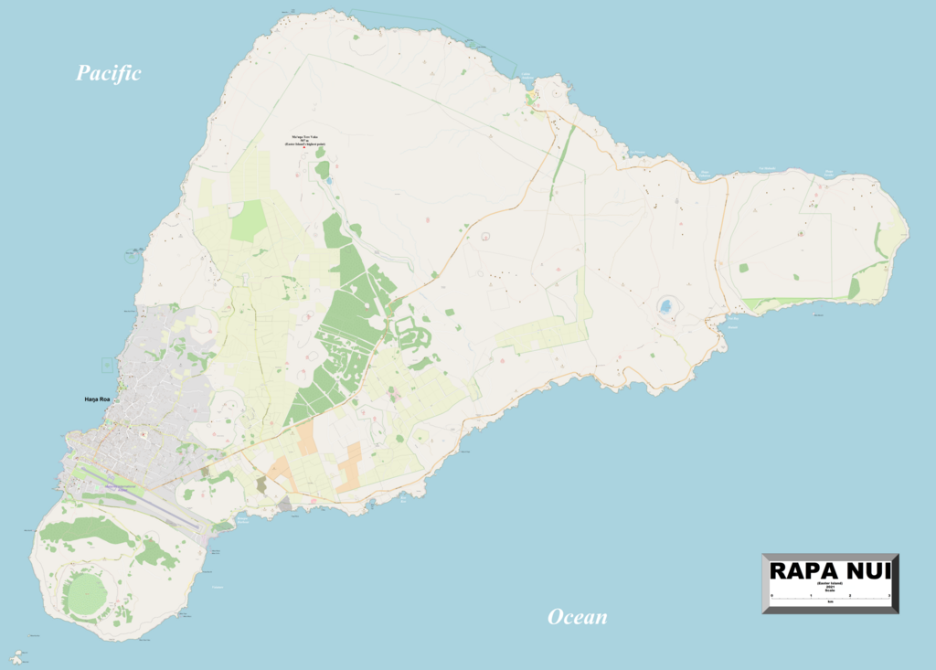
English: This map of Easter Island shows the island's villages and some other geographical details, and is likely the most comprehensive map of the island group in this respect that you'll find anywhere online. It has been stitched together from panels of Open Street Map (which is freely licensed to all) with details plotted by the uploader. |
| Date | |
| Source | http://www.openstreetmap.org/ |
| Author | Kelisi |
| Permission (Reusing this file) |
The aforesaid website is freely usable to all. |
Licensing
edit
I, the copyright holder of this work, hereby publish it under the following license:
This file is licensed under the Creative Commons Attribution-Share Alike 4.0 International license.
- You are free:
- to share – to copy, distribute and transmit the work
- to remix – to adapt the work
- Under the following conditions:
- attribution – You must give appropriate credit, provide a link to the license, and indicate if changes were made. You may do so in any reasonable manner, but not in any way that suggests the licensor endorses you or your use.
- share alike – If you remix, transform, or build upon the material, you must distribute your contributions under the same or compatible license as the original.
File history
Click on a date/time to view the file as it appeared at that time.
| Date/Time | Thumbnail | Dimensions | User | Comment | |
|---|---|---|---|---|---|
| current | 21:37, 25 May 2024 | | 11,000 × 7,877 (9.74 MB) | Kelisi (talk | contribs) | Several more names plotted |
| 18:14, 29 March 2021 |  | 11,000 × 7,877 (8.7 MB) | Kelisi (talk | contribs) | Capital's and airport's names - no more from me. I hear my computer gagging already. | |
| 17:54, 29 March 2021 |  | 11,000 × 7,877 (8.7 MB) | Kelisi (talk | contribs) | This is as much as I dare do, lest my computer choke permanently! | |
| 17:09, 29 March 2021 |  | 11,000 × 7,877 (6.77 MB) | Kelisi (talk | contribs) | Bays and Inlets | |
| 16:44, 29 March 2021 |  | 11,000 × 7,877 (9.71 MB) | Kelisi (talk | contribs) | Headlands and Islands | |
| 01:57, 29 March 2021 |  | 11,000 × 7,877 (6.75 MB) | Kelisi (talk | contribs) | Map finished after computer choked on big file; would like to add more detail but dare not. | |
| 01:43, 29 March 2021 |  | 11,000 × 7,877 (9.67 MB) | Kelisi (talk | contribs) | Uploaded own work with UploadWizard |
You cannot overwrite this file.
File usage on Commons
There are no pages that use this file.
File usage on other wikis
The following other wikis use this file:
- Usage on en.wikipedia.org
- Usage on vi.wikipedia.org