File:EasternBloc-legend.svg

Size of this PNG preview of this SVG file: 405 × 599 pixels. Other resolutions: 162 × 240 pixels | 325 × 480 pixels | 519 × 768 pixels | 693 × 1,024 pixels | 1,385 × 2,048 pixels | 410 × 606 pixels.
Original file (SVG file, nominally 410 × 606 pixels, file size: 1,011 KB)
Captions
Captions
Add a one-line explanation of what this file represents
Summary
edit
| Description |
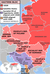
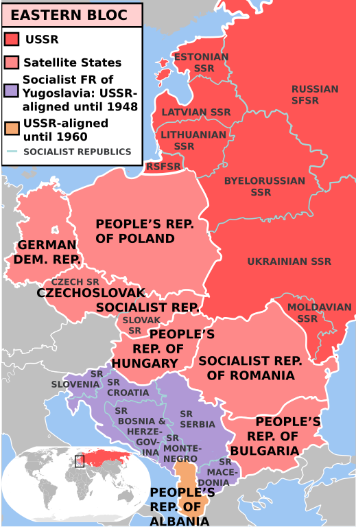
English: * Description: The Eastern Bloc - after the annexations and installations. Dark red is the USSR, pink are Soviet satellite states. Grey borders are SSR and SR borders.
|
| Date | 27 May 2009 (original upload date) |
| Source | Transferred from en.wikipedia to Commons by Sreejithk2000 using CommonsHelper. |
| Author | The original uploader was Mosedschurte at English Wikipedia. |
Licensing
edit

|
Permission is granted to copy, distribute and/or modify this document under the terms of the GNU Free Documentation License, Version 1.2 or any later version published by the Free Software Foundation; with no Invariant Sections, no Front-Cover Texts, and no Back-Cover Texts. A copy of the license is included in the section entitled GNU Free Documentation License. |
| This file is licensed under the Creative Commons Attribution-Share Alike 3.0 Unported license. | ||
| ||
| This licensing tag was added to this file as part of the GFDL licensing update. |
Original upload log
edit
The original description page was here. All following user names refer to en.wikipedia.
- 2009-06-01 18:53 Mosedschurte 410×606× (1035628 bytes)
- 2009-06-01 18:50 Mosedschurte 410×606× (1035628 bytes)
- 2009-06-01 18:47 Mosedschurte 410×606× (1035625 bytes)
- 2009-06-01 18:25 Mosedschurte 410×606× (1034588 bytes) Romania name change
- 2009-06-01 08:22 Mosedschurte 410×606× (1033247 bytes) Mods per comments
- 2009-05-31 23:09 Mosedschurte 410×606× (988900 bytes) legend, svg path compliant, etc.
- 2009-05-28 04:42 Mosedschurte 478×718× (354864 bytes)
- 2009-05-28 04:34 Mosedschurte 478×718× (357653 bytes)
- 2009-05-27 18:50 Mosedschurte 483×721× (473993 bytes) Czech SRs
- 2009-05-27 05:38 Mosedschurte 483×721× (442045 bytes)
- 2009-05-27 05:26 Mosedschurte 483×721× (269319 bytes)
- 2009-05-27 03:27 Mosedschurte 484×733× (413110 bytes) Czech SR
- 2009-05-27 03:01 Mosedschurte 495×725× (420353 bytes) new format
- 2009-05-27 02:38 Mosedschurte 495×725× (64776 bytes) new format
- 2009-05-27 02:25 Mosedschurte 612×792× (64810 bytes) new format
- 2009-05-27 02:23 Mosedschurte 744×1052× (2529 bytes) new format
- 2009-05-27 02:14 Mosedschurte 495×725× (2134 bytes) * Description: The Eastern Bloc - after the annexations and installations. Dark red is the [[USSR]], pink are are Soviet [[satellite states]]. Grey borders are SSR and SR borders. * Source: Own map, based on the maps of the [http://www.lib.utexas.edu/map
File history
Click on a date/time to view the file as it appeared at that time.
| Date/Time | Thumbnail | Dimensions | User | Comment | |
|---|---|---|---|---|---|
| current | 00:32, 4 June 2010 | | 410 × 606 (1,011 KB) | File Upload Bot (Magnus Manske) (talk | contribs) | {{BotMoveToCommons|en.wikipedia|year={{subst:CURRENTYEAR}}|month={{subst:CURRENTMONTHNAME}}|day={{subst:CURRENTDAY}}}} {{Information |Description={{en|* Description: The Eastern Bloc - after the annexations and installations. Dark red is the [[:en:USSR|] |
You cannot overwrite this file.
File usage on Commons
There are no pages that use this file.
File usage on other wikis
The following other wikis use this file:
- Usage on en.wikipedia.org
- Usage on no.wikipedia.org