File:EasternSolomonsChart.jpg
Size of this preview: 559 × 599 pixels. Other resolutions: 224 × 240 pixels | 448 × 480 pixels | 640 × 686 pixels.
Original file (640 × 686 pixels, file size: 90 KB, MIME type: image/jpeg)
Captions
Captions
Add a one-line explanation of what this file represents
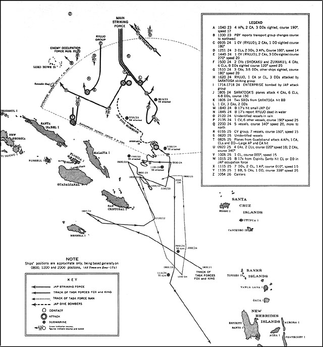
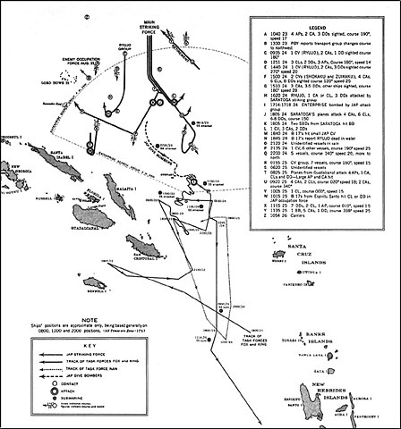
| Description | US Navy map of The Battle of the Eastern Solomons. Tracks of Allied (U.S.) forces are most likely fairly accurate. Tracks of Japanese forces are approximate and/or conjectured. The term "Jap" is used as shorthand for "Japanese" on the map. It's unknown whether this was used pejoratively in this publication or as an accepted abbreviation at that time. |
| Date | |
| Source | US Government ( http://www.ibiblio.org/hyperwar/USN/USN-CN-ESols/index.html )The Battle of the Eastern Solomons, 23-25 August 1942, Navy Department Office of Naval Intelligence, Combat Narrative |
| Author | US Government |
| Permission (Reusing this file) |
US Government/public domain |
This file is a work of a sailor or employee of the U.S. Navy, taken or made as part of that person's official duties. As a work of the U.S. federal government, it is in the public domain in the United States.
|
 | |
| This file has been identified as being free of known restrictions under copyright law, including all related and neighboring rights. | ||
File history
Click on a date/time to view the file as it appeared at that time.
| Date/Time | Thumbnail | Dimensions | User | Comment | |
|---|---|---|---|---|---|
| current | 16:12, 24 May 2006 | | 640 × 686 (90 KB) | Cla68 (talk | contribs) | {{Information| |Description= US Navy map of The Battle of the Eastern Solomons. This map may not be entirely accurate since it was published before World War II was over. |Source= US Government (http://www.ibiblio.org/hyperwar/USN/USN-CN-ESols/index.html |
You cannot overwrite this file.
File usage on Commons
The following page uses this file:
File usage on other wikis
The following other wikis use this file:
- Usage on azb.wikipedia.org
- Usage on cs.wikipedia.org
- Usage on da.wikipedia.org
- Usage on en.wikipedia.org
- Usage on es.wikipedia.org
- Usage on fr.wikipedia.org
- Usage on he.wikipedia.org
- Usage on hu.wikipedia.org
- Usage on id.wikipedia.org
- Usage on ko.wikipedia.org
- Usage on nl.wikipedia.org
- Usage on sr.wikipedia.org
- Usage on vi.wikipedia.org
- Usage on zh.wikipedia.org