File:Eastern Region, Iceland - panoramio (36).jpg

Size of this preview: 800 × 203 pixels. Other resolutions: 320 × 81 pixels | 640 × 162 pixels | 1,024 × 259 pixels | 1,280 × 324 pixels | 7,947 × 2,013 pixels.
Original file (7,947 × 2,013 pixels, file size: 1.49 MB, MIME type: image/jpeg)
Captions
Captions
Add a one-line explanation of what this file represents
Summary edit
.jpg&action=edit§ion=1)
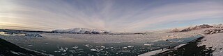
| Description | Eastern Region, Iceland | ||
| Date | Taken on 31 January 2016 | ||
| Source | https://web.archive.org/web/20161102140346/http://www.panoramio.com/photo/127946674 | ||
| Author | Viktar Palstsiuk | ||
| Permission (Reusing this file) |
This file is licensed under the Creative Commons Attribution-Share Alike 3.0 Unported license. Attribution: Viktar Palstsiuk
|
||
| Panoramio Tags | Eastern Region, 2016, Iceland |
| Camera location | | View this and other nearby images on: OpenStreetMap |
|---|
.jpg¶ms=064.049192_N_-016.180775_E_globe:Earth_type:camera_source:Panoramio_&language=en)
File history
Click on a date/time to view the file as it appeared at that time.
| Date/Time | Thumbnail | Dimensions | User | Comment | |
|---|---|---|---|---|---|
| current | 00:54, 26 June 2017 | 7,947 × 2,013 (1.49 MB) | Panoramio upload bot (talk | contribs) | == {{int:filedesc}} == {{Information |description=Eastern Region, Iceland |date={{Taken on|2016-01-31}} |source=http://www.panoramio.com/photo/127946674 |author=[http://www.panoramio.com/user/648165?with_photo_id=127946674 Viktar Palstsiuk] |permission... |
You cannot overwrite this file.
File usage on Commons
There are no pages that use this file.
.jpg&oldid=820317175)