File:Ebola Outbreak Map (ongoing).png

Original file (2,454 × 1,502 pixels, file size: 841 KB, MIME type: image/png)
Captions
Captions

|
This file may be updated to reflect new information. If you wish to use a specific version of the file without new updates being mirrored, please upload the required version as a separate file. |
Summary
edit.png&action=edit§ion=1)
| Description |
English: Continuation of the moribund map located at https://commons.wikimedia.org/wiki/File:Map_of_Ebola_Outbreak_-_1_October_2014.svg |
| Date | |
| Source | Own work |
| Author | Раціональне анархіст |
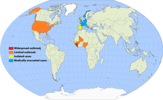
I've undertaken to update an older map, and to simplify the previous cluttered color scheme by removing recorded deaths versus none (a fiddly distinction which required excessive updating). Since a November 20 Wikimedia security rule change, it is apparently no longer possible to upload the .svg scalable format. This file is a 150% .png enlargement of the .svg working document carried over from the previous source.
Suggested rules for updating:
- BLUE: Medically evacuated cases: Any area in which an Ebola case from elsewhere has been treated. Blue regions do not become another color unless there's an actual local outbreak (either due to it escaping the evac facility, or arriving from another source). An ex-blue color cannot become blue again unless it achieves green first (42-day limit passage), then another evac case arrives.
- YELLOW: Isolated cases: Anywhere Ebola is "loose", but for which all or nearly all known and suspected cases are in treatment or quarantine.
- ORANGE: Limited outbreak: An arbitrarily moderate number of persons are infected, including unknown infected "spreaders", but the medical infrastructure is not overwhelmed.
- RED: Widespread outbreak: An out-of-control situation overwhelming available medical infrastructure. Many unidentified infected "spreaders".
Progression: YELLOW > ORANGE > RED > ORANGE > YELLOW.
Please refrain from updating this file if you are not in possession of a master .svg file, and posting a master-derived image in the same format and dimensions as the preceding imagery.
Licensing
edit.png&action=edit§ion=2)

|
Permission is granted to copy, distribute and/or modify this document under the terms of the GNU Free Documentation License, Version 1.2 or any later version published by the Free Software Foundation; with no Invariant Sections, no Front-Cover Texts, and no Back-Cover Texts. A copy of the license is included in the section entitled GNU Free Documentation License. |
- You are free:
- to share – to copy, distribute and transmit the work
- to remix – to adapt the work
- Under the following conditions:
- attribution – You must give appropriate credit, provide a link to the license, and indicate if changes were made. You may do so in any reasonable manner, but not in any way that suggests the licensor endorses you or your use.
- share alike – If you remix, transform, or build upon the material, you must distribute your contributions under the same or compatible license as the original.
File history
Click on a date/time to view the file as it appeared at that time.
.png&dir=prev)
.png&offset=20150807001640)
.png&offset=&limit=20)
.png&offset=&limit=50)
.png&offset=&limit=100)
.png&offset=&limit=250)
.png&offset=&limit=500)
| Date/Time | Thumbnail | Dimensions | User | Comment | |
|---|---|---|---|---|---|
| current | 23:33, 16 September 2017 | | 2,454 × 1,502 (841 KB) | Jamie Tubers (talk | contribs) | According to the discussion had on the article talkpage: https://en.wikipedia.org/wiki/Talk:West_African_Ebola_virus_epidemic/Archive_8#July_2016_map_in_Epidemiology:_Outbreak_section |
| 03:00, 9 April 2017 |  | 2,454 × 1,502 (854 KB) | Agricolae (talk | contribs) | recolor to reflect historical perspective rather than current situation (after outbreak is over everywhere) | |
| 13:16, 14 September 2016 |  | 2,454 × 1,502 (861 KB) | Heitordp (talk | contribs) | Surveillance period ended in all countries | |
| 11:12, 3 April 2016 |  | 2,454 × 1,502 (880 KB) | The Anome (talk | contribs) | Isolated outbreaks in both Guinea and Liberia | |
| 23:14, 31 March 2016 |  | 2,454 × 1,502 (861 KB) | Heitordp (talk | contribs) | Sierra Leone free, new cases in Guinea | |
| 22:05, 7 February 2016 |  | 2,454 × 1,502 (826 KB) | Heitordp (talk | contribs) | Liberia free again, isolated cases in Sierra Leone | |
| 13:58, 29 December 2015 |  | 2,454 × 1,502 (885 KB) | The Anome (talk | contribs) | Guinea now Ebola-free as of 29 December 2015, Liberia only with yellow status now | |
| 01:10, 22 November 2015 |  | 2,454 × 1,502 (826 KB) | Heitordp (talk | contribs) | Sierra Leone free, new case in Liberia | |
| 07:04, 5 September 2015 |  | 2,454 × 1,502 (824 KB) | Раціональне анархіст (talk | contribs) | Liberia clear again. | |
| 00:16, 7 August 2015 |  | 2,454 × 1,502 (824 KB) | Раціональне анархіст (talk | contribs) | Sierra Leone and Guinea improved to yellow after neither country has had more than five new cases per week for two reporting cycles. |
You cannot overwrite this file.
File usage on Commons
The following page uses this file:
File usage on other wikis
The following other wikis use this file:
- Usage on ca.wikipedia.org
- Usage on en.wikipedia.org
- Usage on en.wikiversity.org
- Usage on fi.wikipedia.org
- Usage on fr.wikinews.org
- Usage on hu.wikipedia.org
- Usage on ja.wikipedia.org
- Usage on ko.wikipedia.org
- Usage on no.wikipedia.org
- Usage on pl.wikipedia.org
- Usage on ro.wikipedia.org
- Usage on ru.wikipedia.org
- Usage on rw.wikipedia.org
- Usage on uk.wikipedia.org
- Usage on www.wikidata.org
.png&oldid=822589382)