File:Edayoshijo10.jpg

Size of this preview: 410 × 599 pixels. Other resolutions: 164 × 240 pixels | 329 × 480 pixels | 739 × 1,079 pixels.
Original file (739 × 1,079 pixels, file size: 196 KB, MIME type: image/jpeg)
Captions
Captions
Add a one-line explanation of what this file represents
Summary edit
| Description |
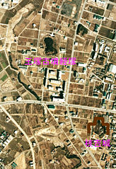
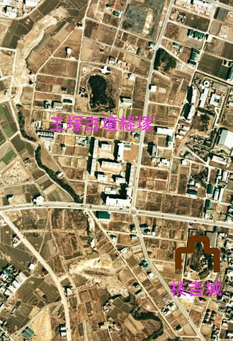
日本語: 枝吉城の位置 |
| Date | 2010/3/3にファイル作成,1979年(昭和49年度)に撮影 |
| Source | 国土画像情報(カラー空中写真)国土交通省http://w3land.mlit.go.jp/Air/photo400/74/ckk-74-14/c36a/ckk-74-14_c36a_4.jpg |
| Author | 投稿者がファイル作成 |
[説明]
国土交通省の国土画像情報(カラー空中写真)を元に作成。
- 整理番号:CKK-74-14
- 撮影年度:昭和49年度
- 撮影コース:C36A
- 写真番号:4
Licensing edit

|
The copyright holder of this file, the Ministry of Land, Infrastructure, Transport and Tourism of Japan, allows anyone to use it for any purpose, provided that the copyright holder is properly attributed. Redistribution, derivative work, commercial use, and all other use is permitted. |
Attribution:
Copyright © National Land Image Information (Color Aerial Photographs), Ministry of Land, Infrastructure, Transport and Tourism
|
 |
This image is copyrighted by the Ministry of Land, Infrastructure, Transport and Tourism of Japan. For terms of use, see the stipulation to use of National Land Information (in Japanese) and message from MLIT (in Japanese and English). When you display this image on an article, include the following phrase in the description: "Made based on National Land Image Information (Color Aerial Photographs), Ministry of Land, Infrastructure, Transport and Tourism".
|
File history
Click on a date/time to view the file as it appeared at that time.
| Date/Time | Thumbnail | Dimensions | User | Comment | |
|---|---|---|---|---|---|
| current | 08:47, 3 March 2010 | | 739 × 1,079 (196 KB) | ブレイズマン~commonswiki (talk | contribs) | {{Information |Description={{ja|1=枝吉城の位置}} |Source=国土画像情報(カラー空中写真)国土交通省http://w3land.mlit.go.jp/Air/photo400/74/ckk-74-14/c36a/ckk-74-14_c36a_4.jpg |Author=投稿者がファイル作成 |Date=2010/3/3� |
You cannot overwrite this file.
File usage on Commons
The following page uses this file:
File usage on other wikis
The following other wikis use this file: