File:Edgeøya and Barentsøya landsat7.jpg

Size of this preview: 467 × 599 pixels. Other resolutions: 187 × 240 pixels | 374 × 480 pixels | 599 × 768 pixels | 798 × 1,024 pixels | 1,596 × 2,048 pixels | 5,529 × 7,093 pixels.
Original file (5,529 × 7,093 pixels, file size: 19.76 MB, MIME type: image/jpeg)
Captions
Captions
Add a one-line explanation of what this file represents
Summary
edit
| Description |
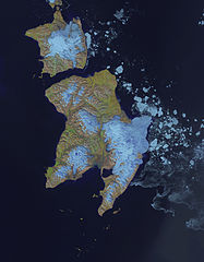
Deutsch: Landsat 7 Satellitenbild der Spitzbergen/Svalbard Inseln Edgeøya (unten) und Barentsøya (oben) vom 12. Juli 2002 |
| Date | |
| Source | Landsat 7 |
| Author | NASA Landsat 7 |
| Camera location | | View this and other nearby images on: OpenStreetMap |
|---|
Licensing
edit
| This file is in the public domain in the United States because it was solely created by NASA. NASA copyright policy states that "NASA material is not protected by copyright unless noted". (See Template:PD-USGov, NASA copyright policy page or JPL Image Use Policy.) | ||
 |
Warnings:
|
File history
Click on a date/time to view the file as it appeared at that time.
| Date/Time | Thumbnail | Dimensions | User | Comment | |
|---|---|---|---|---|---|
| current | 00:01, 27 November 2013 | | 5,529 × 7,093 (19.76 MB) | Ubahnverleih (talk | contribs) | User created page with UploadWizard |
You cannot overwrite this file.
File usage on Commons
There are no pages that use this file.
File usage on other wikis
The following other wikis use this file:
- Usage on de.wikipedia.org
- Usage on fr.wikipedia.org