File:Effects of the drought on Lake Mead, USA (Copernicus).jpg

Original file (4,000 × 2,540 pixels, file size: 7.56 MB, MIME type: image/jpeg)
Captions
Captions
Summary
edit.jpg&action=edit§ion=1)
| Description |
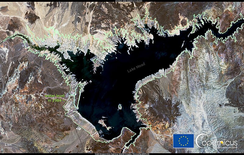
English: This image, acquired by one of the Copernicus Sentinel-2 satellites on 14 July 2021, shows the current state of Lake Mead in the United States. Comparing the water level in the latest Sentinel-2 image with an extrapolation from a Landsat-5 image acquired in October 1984 (green line) shows that the level of the lake has significantly dropped in several points, with the coastline retreating by more than one kilometre in 37 years. As of June 2021, the level of Lake Mead has dropped to about a third of its total capacity and is at its lowest point in the lake's history. As a consequence of water levels, cuts in downstream water allocations from the Colorado river are planned for 2022. According to experts, the mega-drought that is affecting the west coast of the United States is driven by climate change and is leading to an irreversible aridification of the territory. Data acquired by the Copernicus Sentinel satellites are used to detect and monitor water bodies globally. |
| Date | Taken on 14 July 2021 |
| Source | Effects of the drought on Lake Mead, USA |
| Author | European Union, Copernicus Sentinel-2 Imagery |
Licensing
edit.jpg&action=edit§ion=2)

|
This image contains data from a satellite in the Copernicus Programme, such as Sentinel-1, Sentinel-2 or Sentinel-3. Attribution is required when using this image.
Attribution: Contains modified Copernicus Sentinel data 2021
The use of Copernicus Sentinel Data is regulated under EU law (Commission Delegated Regulation (EU) No 1159/2013 and Regulation (EU) No 377/2014). Relevant excerpts:
Free access shall be given to GMES dedicated data [...] made available through GMES dissemination platforms [...].
Access to GMES dedicated data [...] shall be given for the purpose of the following use in so far as it is lawful:
GMES dedicated data [...] may be used worldwide without limitations in time.
GMES dedicated data and GMES service information are provided to users without any express or implied warranty, including as regards quality and suitability for any purpose. |
File history
Click on a date/time to view the file as it appeared at that time.
| Date/Time | Thumbnail | Dimensions | User | Comment | |
|---|---|---|---|---|---|
| current | 14:27, 9 September 2023 | | 4,000 × 2,540 (7.56 MB) | OptimusPrimeBot (talk | contribs) | #Spacemedia - Upload of https://www.copernicus.eu/system/files/2021-07/image_day/20210716_DroughtOfLakeMead_2.jpg via Commons:Spacemedia |
You cannot overwrite this file.
File usage on Commons
There are no pages that use this file.
.jpg&oldid=799990739)