File:Elecciones generales españolas de 1996 - distribución del voto.svg

Size of this PNG preview of this SVG file: 572 × 388 pixels. Other resolutions: 320 × 217 pixels | 640 × 434 pixels | 1,024 × 695 pixels | 1,280 × 868 pixels | 2,560 × 1,737 pixels.
Original file (SVG file, nominally 572 × 388 pixels, file size: 1.46 MB)
Captions
Captions
Add a one-line explanation of what this file represents
| Description |
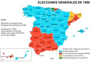
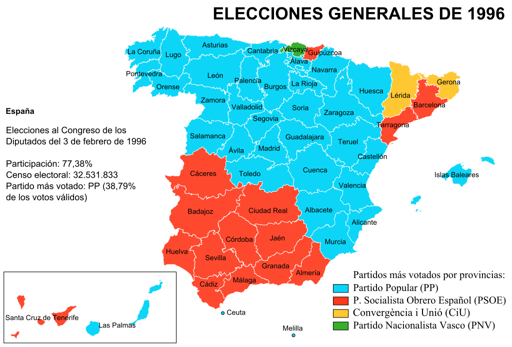
Mapa de las elecciones generales españolas de 1996 (elecciones al congreso de Diputados): voto mayoritario por provincias. Nota: en Huesca, Zaragoza y Teruel el Partido Popular (PP) se presentó en coalición con el Partido Aragonés Regionalista (PAR). |
||
| Date | |||
| Source | Ministerio del Interior de España - Base histórica de resultados electorales | ||
| Author | Creado por Rodriguillo, tomando como mapa base Image:Provinces of Spain.svg | ||
| Permission (Reusing this file) |
|
||
| Other versions | Image:Elecciones generales españolas de 1996 - distribución del voto.png |
File history
Click on a date/time to view the file as it appeared at that time.
| Date/Time | Thumbnail | Dimensions | User | Comment | |
|---|---|---|---|---|---|
| current | 14:23, 28 May 2010 | | 572 × 388 (1.46 MB) | Kizar (talk | contribs) | optimized |
| 17:36, 10 March 2008 |  | 572 × 388 (2.24 MB) | Rodriguillo (talk | contribs) | {{Information |Description= Mapa de las '''elecciones generales españolas de 1996''' (elecciones al congreso de Diputados): voto mayoritario por provincias. |Source= Ministerio del Interior de España - [http://www.elecciones.mir.es/MIR/jsp/resultados/in |
You cannot overwrite this file.
File usage on Commons
The following 2 pages use this file:
File usage on other wikis
The following other wikis use this file:
- Usage on en.wikipedia.org
- Usage on es.wikipedia.org
- Usage on fi.wikipedia.org
- Usage on gl.wikipedia.org
- Usage on ja.wikipedia.org