File:Electoral systems for heads of state map.svg

Size of this PNG preview of this SVG file: 800 × 411 pixels. Other resolutions: 320 × 164 pixels | 640 × 329 pixels | 1,024 × 526 pixels | 1,280 × 657 pixels | 2,560 × 1,314 pixels | 863 × 443 pixels.
Original file (SVG file, nominally 863 × 443 pixels, file size: 1.68 MB)
Captions
Captions
Add a one-line explanation of what this file represents
Summary
edit
| Description |
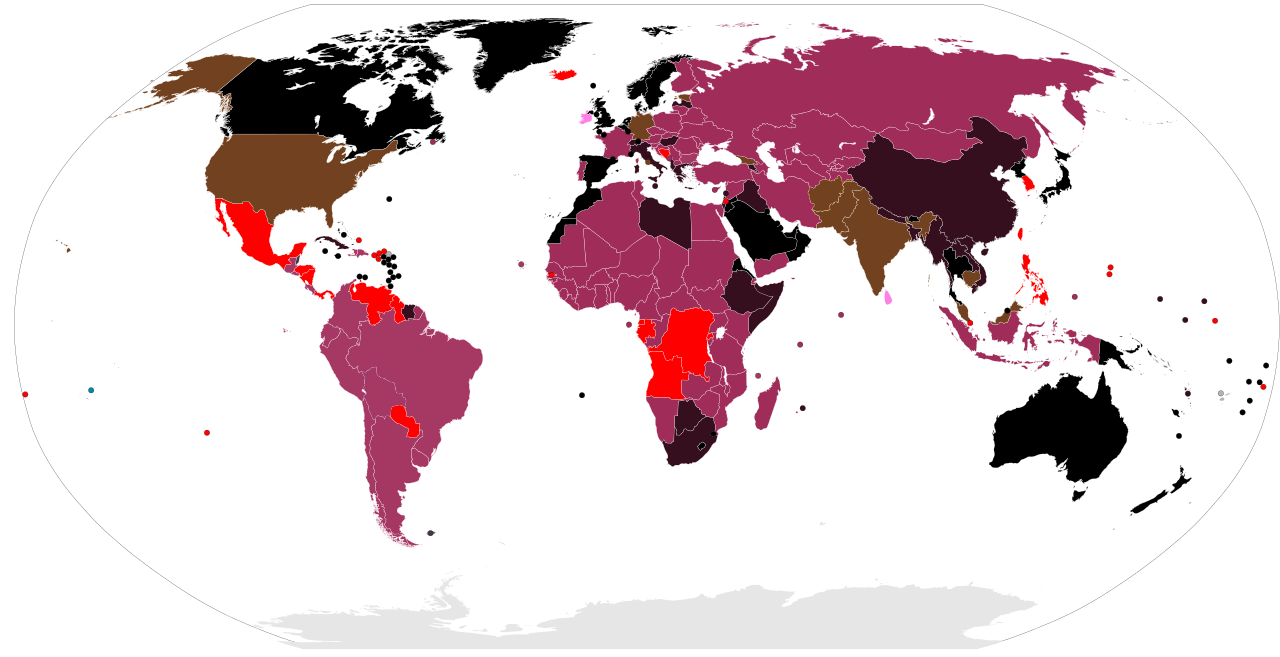
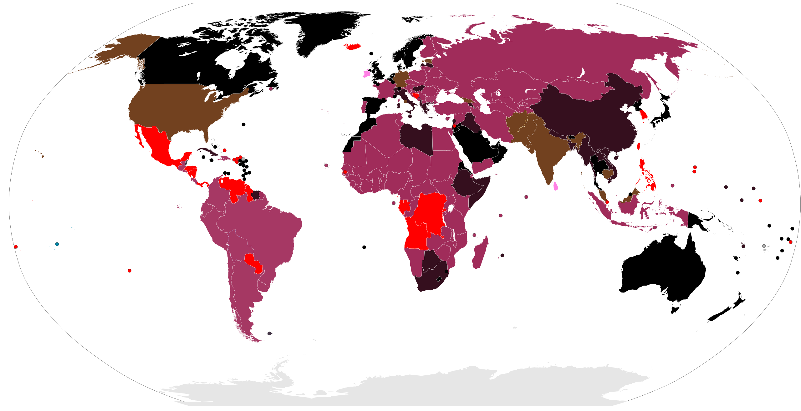
English: Legend:
First past the post (FPTP)
Two-round system (TRS)
Instant-runoff voting, including contingent voting (IRV)
Election by legislature
Election by electoral college
Election by legislature (first rounds) and electoral college (or bodies which are not wholly legislatures; subsequent rounds)
unused: Confirmation by referendum after election by party
Not elected (mostly monarchies)
In transition
Unused
No information |
| Date | |
| Source | File:BlankMap-World-Microstates.svg |
| Author | VARIOUS |
Licensing
edit
| This file is made available under the Creative Commons CC0 1.0 Universal Public Domain Dedication. | |
| The person who associated a work with this deed has dedicated the work to the public domain by waiving all of their rights to the work worldwide under copyright law, including all related and neighboring rights, to the extent allowed by law. You can copy, modify, distribute and perform the work, even for commercial purposes, all without asking permission.
|
File history
Click on a date/time to view the file as it appeared at that time.
| Date/Time | Thumbnail | Dimensions | User | Comment | |
|---|---|---|---|---|---|
| current | 03:13, 29 May 2023 | | 863 × 443 (1.68 MB) | TEMPO156 (talk | contribs) | Updated Afghanistan to election by unelected body. The Leadership Council is no longer considered a legislature |
| 19:46, 5 July 2022 |  | 863 × 443 (1.68 MB) | TEMPO156 (talk | contribs) | Update Afghanistan (elected by legislative body) | |
| 18:07, 14 June 2022 |  | 863 × 443 (1.68 MB) | Rankedchoicevoter (talk | contribs) | changed colors | |
| 14:01, 30 April 2022 |  | 863 × 443 (1.68 MB) | Rankedchoicevoter (talk | contribs) | colors | |
| 08:07, 2 July 2020 |  | 863 × 443 (1.67 MB) | Glide08 (talk | contribs) | Corrected Tanzania, Kenya, Uganda, Zambia, Zimbabwe, Central Africa and Seychelles to two-round. Corrected Guyana to first-past-the-post (Both Angola and Guyana elect the lijsttrekker of the most-voted-for-party in the parliamentary election as President). Corrected Gibraltar to null (it previously had the Block voting color - likely a holdover from the parliamentary election map). Updated Malawi to two-round. Updated Georgia to Electoral College. Changed Cambodia and Burkina into actual... | |
| 15:06, 16 April 2018 |  | 863 × 443 (1.67 MB) | Alghenius (talk | contribs) | corrections | |
| 16:54, 10 January 2015 |  | 863 × 443 (1.67 MB) | Øln (talk | contribs) | Tunisia, Sudan, South Sudan, Syria, Mongolia -> two round system DR Congo -> FPTP | |
| 19:21, 18 January 2013 |  | 863 × 443 (1.67 MB) | Howard the Duck (talk | contribs) | Cambodia = electoral college | |
| 01:12, 14 January 2013 |  | 863 × 443 (1.67 MB) | Howard the Duck (talk | contribs) | some more updates | |
| 01:05, 14 January 2013 |  | 863 × 443 (1.67 MB) | Howard the Duck (talk | contribs) | missed out on some countries |
You cannot overwrite this file.
File usage on Commons
There are no pages that use this file.
File usage on other wikis
The following other wikis use this file:
- Usage on en.wikipedia.org
- Usage on hu.wikipedia.org
- Usage on ru.wikipedia.org
- Usage on tr.wikipedia.org