File:Ennerdale Water jetty - geograph.org.uk - 991157.jpg
No higher resolution available.
Ennerdale_Water_jetty_-_geograph.org.uk_-_991157.jpg (600 × 450 pixels, file size: 101 KB, MIME type: image/jpeg)
Captions
Captions
Add a one-line explanation of what this file represents
Summary
edit
| Description |
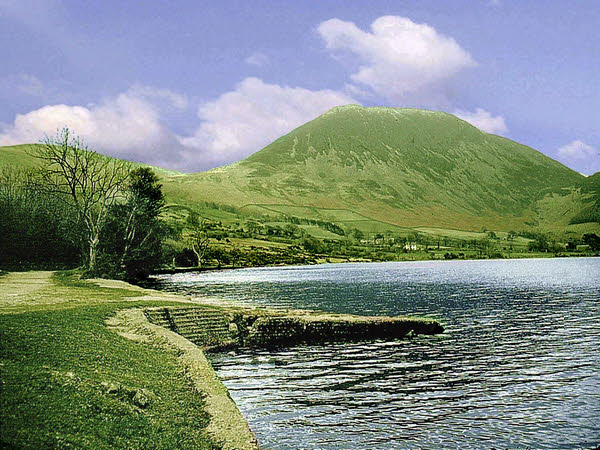
English: Ennerdale Water jetty This picture of the jetty was taken from the site of the old Anglers Inn after it had been demolished. The inn was demolished in 1961 ready for the raising of the water level by four feet. The battle for planning permission for raising the level raged for twenty years until 1981 when Michael Heseltine finally refused consent. Thus the inn was unfortunately demolished unnecessarily, leaving just the jetty. |
| Date | |
| Source | From geograph.org.uk |
| Author | Anthony Harrison |
| Attribution (required by the license) | Anthony Harrison / Ennerdale Water jetty / |
| Camera location | | View this and other nearby images on: OpenStreetMap |
|---|
_heading:45.00&language=en)
| Object location | | View this and other nearby images on: OpenStreetMap |
|---|
_heading:45.00&language=en)
Licensing
edit

|
This image was taken from the Geograph project collection. See this photograph's page on the Geograph website for the photographer's contact details. The copyright on this image is owned by Anthony Harrison and is licensed for reuse under the Creative Commons Attribution-ShareAlike 2.0 license.
|
This file is licensed under the Creative Commons Attribution-Share Alike 2.0 Generic license.
Attribution: Anthony Harrison
- You are free:
- to share – to copy, distribute and transmit the work
- to remix – to adapt the work
- Under the following conditions:
- attribution – You must give appropriate credit, provide a link to the license, and indicate if changes were made. You may do so in any reasonable manner, but not in any way that suggests the licensor endorses you or your use.
- share alike – If you remix, transform, or build upon the material, you must distribute your contributions under the same or compatible license as the original.
File history
Click on a date/time to view the file as it appeared at that time.
| Date/Time | Thumbnail | Dimensions | User | Comment | |
|---|---|---|---|---|---|
| current | 03:54, 23 February 2011 | | 600 × 450 (101 KB) | GeographBot (talk | contribs) | == {{int:filedesc}} == {{Information |description={{en|1=Ennerdale Water jetty This picture of the jetty was taken from the site of the old Anglers Inn after it had been demolished. The inn was demolished in 1961 ready for the raising of the water level |
You cannot overwrite this file.
File usage on Commons
There are no pages that use this file.