File:Entwicklung Eisenbahnnetz Karlsruhe.png

Size of this preview: 800 × 573 pixels. Other resolutions: 320 × 229 pixels | 640 × 459 pixels | 1,024 × 734 pixels | 1,280 × 917 pixels | 1,574 × 1,128 pixels.
Original file (1,574 × 1,128 pixels, file size: 1.72 MB, MIME type: image/png)
Captions
Captions
Add a one-line explanation of what this file represents
Summary edit
| Description |
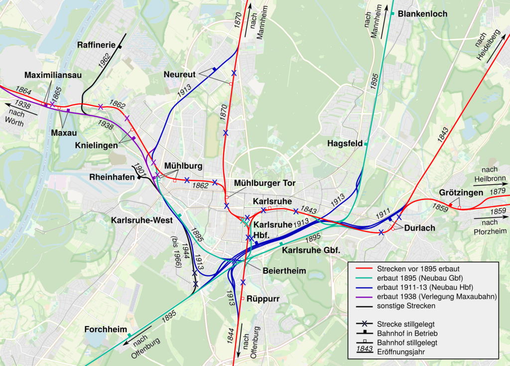
Deutsch: Historische Entwicklung des Eisenbahnnetzes in Karlsruhe. Ohne Neben- und Kleinbahnen (Albtalbahn, Karlsruher Lokalbahn) sowie nichtstaatliche Strecken (NE-Bahnen) |
| Date | |
| Source | OpenStreetMap und eigenes Werk |
| Author | OpenStreetMap und MCMC (talk) 12:32, 3 December 2023 (UTC) |
Licensing edit
| Description |
This map was created from OpenStreetMap project data, collected by the community. This map may be incomplete, and may contain errors. Don't rely solely on it for navigation. |
|||
| Date | (see file history) | |||
| Source | openstreetmap.org | |||
| Creator |
OpenStreetMap contributors |
|||
| Permission (Reusing this file) |
OpenStreetMap data is available under the Open Database License (details). Map tiles are licensed under the Creative Commons Attribution-ShareAlike 2.0 license (CC-BY-SA 2.0).
This file is licensed under the Creative Commons Attribution-Share Alike 2.0 Generic license.
|
|||
| Georeferencing | If inappropriate please set warp_status = skip to hide. |
File history
Click on a date/time to view the file as it appeared at that time.
| Date/Time | Thumbnail | Dimensions | User | Comment | |
|---|---|---|---|---|---|
| current | 17:54, 23 December 2023 | | 1,574 × 1,128 (1.72 MB) | MCMC (talk | contribs) | Korrektur Bildausschnitt |
| 17:51, 23 December 2023 |  | 967 × 1,368 (1.25 MB) | MCMC (talk | contribs) | Korrektur der Strecke Mühlburg - Neureut | |
| 12:32, 3 December 2023 |  | 1,574 × 1,128 (1.71 MB) | MCMC (talk | contribs) | Uploaded a work by OpenStreetMap und ~~~~ from OpenStreetMap und eigenes Werk with UploadWizard |
You cannot overwrite this file.
File usage on Commons
The following 6 pages use this file:
- User:Chumwa/OgreBot/Public transport information/2023 December 1-10
- User:Chumwa/OgreBot/Public transport information/2023 December 21-31
- User:Chumwa/OgreBot/Transport Maps/2023 December 1-10
- User:Chumwa/OgreBot/Transport Maps/2023 December 21-31
- User:Ireas/OgreBot/Karlsruhe/2023 December 1-10
- User:Ireas/OgreBot/Karlsruhe/2023 December 21-31
File usage on other wikis
The following other wikis use this file:
- Usage on de.wikipedia.org
- Usage on ja.wikipedia.org