File:Equateur @mabilarene.jpg

Size of this preview: 602 × 600 pixels. Other resolutions: 241 × 240 pixels | 482 × 480 pixels | 793 × 790 pixels.
Original file (793 × 790 pixels, file size: 61 KB, MIME type: image/jpeg)
Captions
Captions
Add a one-line explanation of what this file represents
Summary edit
| Description |
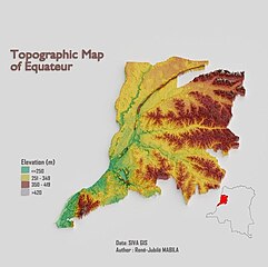
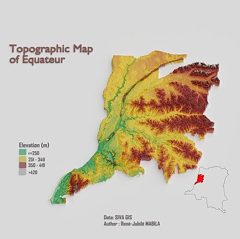
English: Topographic Map of Equateur (DR Congo) made by René-Jubilé MABILA
Français : Carte topographique de la province de l'Equateur en RD Congo effectué par René-Jubilé MABILA |
| Date | |
| Source | https://github.com/Rene-Jubile/3d-drc-topographic-map/blob/main/imgs/Equateur%20@mabilarene.jpg |
| Author | René-Jubilé MABILA |
Licensing edit
This file is licensed under the Creative Commons Attribution-Share Alike 4.0 International license.
- You are free:
- to share – to copy, distribute and transmit the work
- to remix – to adapt the work
- Under the following conditions:
- attribution – You must give appropriate credit, provide a link to the license, and indicate if changes were made. You may do so in any reasonable manner, but not in any way that suggests the licensor endorses you or your use.
- share alike – If you remix, transform, or build upon the material, you must distribute your contributions under the same or compatible license as the original.
File history
Click on a date/time to view the file as it appeared at that time.
| Date/Time | Thumbnail | Dimensions | User | Comment | |
|---|---|---|---|---|---|
| current | 16:21, 15 November 2023 | | 793 × 790 (61 KB) | Rju9 (talk | contribs) | Uploaded a work by René-Jubilé MABILA from https://github.com/Rene-Jubile/3d-drc-topographic-map/blob/main/imgs/Equateur%20@mabilarene.jpg with UploadWizard |
You cannot overwrite this file.
File usage on Commons
There are no pages that use this file.