File:Equirectangular image of Platja de les Anquines and the coast of Sitges, Spain (1).png
Size of this preview: 800 × 400 pixels. Other resolutions: 320 × 160 pixels | 640 × 320 pixels | 1,024 × 512 pixels | 1,280 × 640 pixels | 2,560 × 1,280 pixels | 18,726 × 9,363 pixels.
Original file (18,726 × 9,363 pixels, file size: 151.14 MB, MIME type: image/png)
File information
Structured data
Captions
Summary
editDescriptionEquirectangular image of Platja de les Anquines and the coast of Sitges, Spain (1).png |
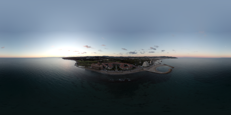
English: Equirectangular image of Platja de les Anquines and the coast of Sitges, Spain. |
Date | |
Source | Own work |
Author | Ckoerner |
Licensing
editI, the copyright holder of this work, hereby publish it under the following license:
This file is licensed under the Creative Commons Attribution 4.0 International license.
- You are free:
- to share – to copy, distribute and transmit the work
- to remix – to adapt the work
- Under the following conditions:
- attribution – You must give appropriate credit, provide a link to the license, and indicate if changes were made. You may do so in any reasonable manner, but not in any way that suggests the licensor endorses you or your use.
File history
Click on a date/time to view the file as it appeared at that time.
Date/Time | Thumbnail | Dimensions | User | Comment | |
---|---|---|---|---|---|
current | 02:02, 2 April 2024 | 18,726 × 9,363 (151.14 MB) | Ckoerner (talk | contribs) | Uploaded own work with UploadWizard |
You cannot overwrite this file.
File usage on Commons
There are no pages that use this file.
Metadata
This file contains additional information such as Exif metadata which may have been added by the digital camera, scanner, or software program used to create or digitize it. If the file has been modified from its original state, some details such as the timestamp may not fully reflect those of the original file. The timestamp is only as accurate as the clock in the camera, and it may be completely wrong.
ISO speed rating | 100 |
---|---|
Longitude | 1° 47′ 8.92″ E |
Latitude | 41° 13′ 23.12″ N |
Exposure time | 1/120 sec (0.0083333333333333) |
Lens focal length | 4.4899997708997 mm |
F-number | f/2.8 |
Altitude | 11.271 meters below sea level |
Camera manufacturer | DJI |
Camera model | FC7303 |
Date and time of data generation | 19:24, 4 October 2022 |
Serial number of camera | 1SFOHAS0AB0NBF |
Lens used | 20.7 mm |
Exif version | 2.3 |
Saturation | Normal |
White balance | Auto white balance |
Exposure mode | Auto exposure |
Image height | 9,363 px |
Maximum land aperture | 2.970000028615 APEX (f/2.8) |
GPS tag version | 2.3.0.0 |
APEX aperture | 2.970000028615 |
Custom image processing | Normal process |
File source | Digital still camera |
Light source | Daylight |
APEX shutter speed | 6.9067997921461 |
Scene capture type | Standard |
Scene control | None |
Exposure Program | Normal program |
Contrast | Normal |
Metering mode | Center weighted average |
Scene type | A directly photographed image |
Flash | Flash did not fire, No flash function |
Image width | 18,726 px |
Sharpness | Normal |
Compression scheme | Uncompressed |
Panorama cropped height | 9,363 |
Panorama left crop | 0 |
Panorama top crop | 0 |
Panorama full height | 9,363 |
Panorama cropped width | 18,726 |
Panorama full width | 18,726 |
Use panorama viewer | Yes |
Projection type | Equirectangular |
File change date and time | 19:24, 4 October 2022 |
Date and time of digitizing | 19:24, 4 October 2022 |
Software used | Panorama Stitcher 1.12.1 |