File:Equirectangular projection with grid only.svg

Size of this PNG preview of this SVG file: 501 × 251 pixels. Other resolutions: 320 × 160 pixels | 640 × 321 pixels | 1,024 × 513 pixels | 1,280 × 641 pixels | 2,560 × 1,283 pixels.
Original file (SVG file, nominally 501 × 251 pixels, file size: 65 KB)
Captions
Captions
Add a one-line explanation of what this file represents
Summary
edit
| Description |
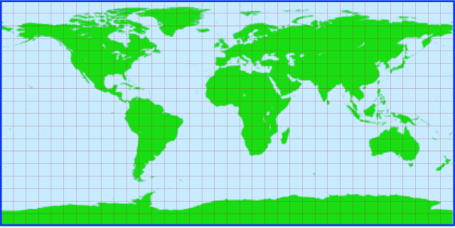
English: World map on the equirectangular projection (or plane chart or Plate Carree). The graticule spacing is 10 degrees. This is a low resolution figure, unsuitable for zoom. The figure was produced in Inkscape 1.47 with (public domain ) data from the NGDC World Coast Line. |
| Date | |
| Source | Own work |
| Author | Peter Mercator |
Licensing
edit
| This file is made available under the Creative Commons CC0 1.0 Universal Public Domain Dedication. | |
| The person who associated a work with this deed has dedicated the work to the public domain by waiving all of their rights to the work worldwide under copyright law, including all related and neighboring rights, to the extent allowed by law. You can copy, modify, distribute and perform the work, even for commercial purposes, all without asking permission.
|
File history
Click on a date/time to view the file as it appeared at that time.
| Date/Time | Thumbnail | Dimensions | User | Comment | |
|---|---|---|---|---|---|
| current | 21:41, 12 August 2010 | | 501 × 251 (65 KB) | Peter Mercator (talk | contribs) | Try embedding images. |
| 20:59, 12 August 2010 |  | 464 × 225 (18 KB) | Peter Mercator (talk | contribs) | {{Information |Description={{en|1=World map on the equirectangular projection (or plane chart or Plate Carree). The graticule spacing is 10 degrees. This is a low resolution figure, unsuitable for zoom. The figure was produced in Inkscape 1.47 with (publ |
You cannot overwrite this file.
File usage on Commons
There are no pages that use this file.
File usage on other wikis
The following other wikis use this file:
- Usage on fr.wikipedia.org