File:Erding Ring Closure.png

Size of this preview: 733 × 600 pixels. Other resolutions: 293 × 240 pixels | 587 × 480 pixels | 848 × 694 pixels.
Original file (848 × 694 pixels, file size: 646 KB, MIME type: image/png)
Captions
Captions
Add a one-line explanation of what this file represents
Summary
edit
| Description |
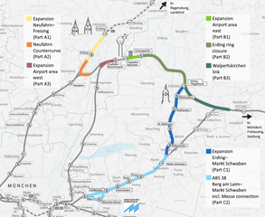
English: Overview of planned projects to connect Munich airport with east Bavaria: Neufahrn Countercurve, Erding Ring Closure, Walpertskirchen Link, S-Bahn München Riem–Erding, railway München–Mühldorf(–Freilassing) |
| Date | |
| Source |
Own work. This file was derived from: Erdinger Ringschluss.png The original legends and "to" indications in German have been converted to English. |
| Author | Qui1che |
Licensing
edit
I, the copyright holder of this work, hereby publish it under the following license:
| This file is made available under the Creative Commons CC0 1.0 Universal Public Domain Dedication. | |
| The person who associated a work with this deed has dedicated the work to the public domain by waiving all of their rights to the work worldwide under copyright law, including all related and neighboring rights, to the extent allowed by law. You can copy, modify, distribute and perform the work, even for commercial purposes, all without asking permission.
|
File history
Click on a date/time to view the file as it appeared at that time.
| Date/Time | Thumbnail | Dimensions | User | Comment | |
|---|---|---|---|---|---|
| current | 23:07, 21 May 2016 | | 848 × 694 (646 KB) | Qui1che (talk | contribs) | User created page with UploadWizard |
You cannot overwrite this file.
File usage on Commons
The following 8 pages use this file:
- User:Chumwa/OgreBot/München/2016 May 21-31
- User:Chumwa/OgreBot/Potential transport maps/2016 May 21-31
- User:Chumwa/OgreBot/Public transport information/2016 May 21-31
- User:Chumwa/OgreBot/Transport Maps/2016 May 21-31
- User:Chumwa/OgreBot/Travel and communication maps/2016 May 21-31
- User:Vuxi/Neue Bilder in Freising/2016 May
- Commons:WikiProject Aviation/recent uploads/2016 May 21
- Category:Neufahrner Kurve
File usage on other wikis
The following other wikis use this file:
- Usage on de.wikipedia.org
- Usage on en.wikipedia.org
- Usage on www.wikidata.org