File:Erkrath Hochdahl.png

Size of this preview: 586 × 599 pixels. Other resolutions: 235 × 240 pixels | 469 × 480 pixels | 710 × 726 pixels.
Original file (710 × 726 pixels, file size: 70 KB, MIME type: image/png)
Captions
Captions
Add a one-line explanation of what this file represents

|
This transport map image could be re-created using vector graphics as an SVG file. This has several advantages; see Commons:Media for cleanup for more information. If an SVG form of this image is available, please upload it and afterwards replace this template with
{{vector version available|new image name}}.
It is recommended to name the SVG file “Erkrath Hochdahl.svg”—then the template Vector version available (or Vva) does not need the new image name parameter. |
| Description |
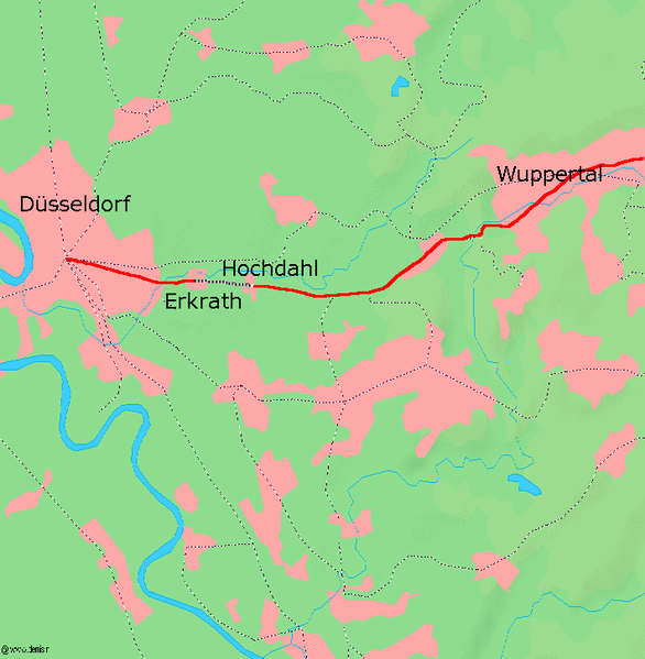
Deutsch: Karte der Stammstrecke der Bergisch-Märkischen Eisenbahn mit eingezeichneter de:Steilrampe Erkrath-Hochdahl, Kartenquelle: [1] de:Benutzer:Markus Schweià |
| Date | 11 June 2006 (original upload date) |
| Source | Transferred from de.wikipedia to Commons by Atamari using CommonsHelper. |
| Author | The original uploader was Markus Schweià at German Wikipedia. |
Licensing
edit

|
Permission is granted to copy, distribute and/or modify this document under the terms of the GNU Free Documentation License, Version 1.2 or any later version published by the Free Software Foundation; with no Invariant Sections, no Front-Cover Texts, and no Back-Cover Texts. A copy of the license is included in the section entitled GNU Free Documentation License. |
| This file is licensed under the Creative Commons Attribution-Share Alike 3.0 Unported license. | ||
| ||
| This licensing tag was added to this file as part of the GFDL licensing update. |
Original upload log
edit
The original description page was here. All following user names refer to de.wikipedia.
- 2006-06-11 14:56 Walter Koch 710×726× (71574 bytes)
- 2004-10-17 07:50 Markus Schweià 710×726× (69168 bytes) Karte der Stammstrecke der Bergisch-Märkischen Eisenbahn mit eingezeichneter [[Steilrampe Erkrath-Hochdahl]], Kartenquelle: [http://www.demis.nl/mapserver/mapper.asp] {{Bild-GFDL}} [[Benutzer:Markus SchweiÃ]]
File history
Click on a date/time to view the file as it appeared at that time.
| Date/Time | Thumbnail | Dimensions | User | Comment | |
|---|---|---|---|---|---|
| current | 01:15, 19 January 2009 | | 710 × 726 (70 KB) | File Upload Bot (Magnus Manske) (talk | contribs) | {{BotMoveToCommons|de.wikipedia}} {{Information |Description={{de|Karte der Stammstrecke der Bergisch-Märkischen Eisenbahn mit eingezeichneter de:Steilrampe Erkrath-Hochdahl, Kartenquelle: [http://www.demis.nl/mapserver/mapper.asp] [[:de:Benutz |
You cannot overwrite this file.
File usage on Commons
The following page uses this file:
File usage on other wikis
The following other wikis use this file:
- Usage on azb.wikipedia.org
- Usage on de.wikipedia.org
- Usage on en.wikipedia.org
- Usage on fr.wikipedia.org
- Usage on www.wikidata.org