File:Eroded stone channel, Freshwater Steps - geograph.org.uk - 900669.jpg
Size of this preview: 450 × 600 pixels. Other resolutions: 180 × 240 pixels | 480 × 640 pixels.
Original file (480 × 640 pixels, file size: 133 KB, MIME type: image/jpeg)
Captions
Captions
Add a one-line explanation of what this file represents
Summary edit
| Description |
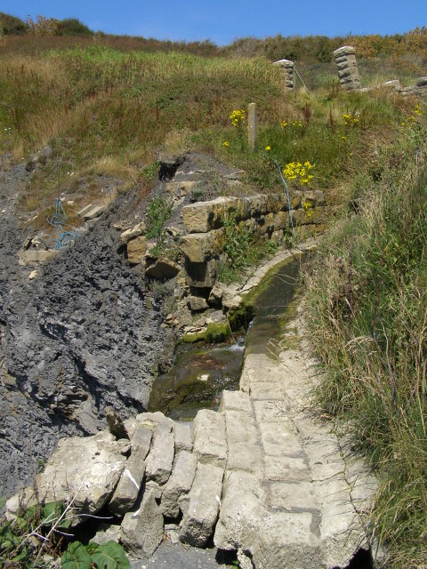
English: Eroded stone channel, Freshwater Steps This stone culvert once channelled the South Gwyle stream from Encombe to the end of the small promontory at the western end of Egmont Bight. It is slowly being destroyed by the erosion of the promontory. To the left the blue rope marks the location of the now defunct 'Freshwater Steps' - a flight of stone steps leading down to the beach, originally for the use of the residents of Encombe House. The blue rope is presumably for emergency ascent from the beach - there is no easy access to the beach except by walking along the coast from Kimmeridge Bay!
Here the stream (little more than a trickle after a short dry spell) is dropping off the west side of the promontory as a waterfall. |
| Date | |
| Source | From geograph.org.uk |
| Author | Jim Champion |
| Attribution (required by the license) | Jim Champion / Eroded stone channel, Freshwater Steps / |
| Camera location | | View this and other nearby images on: OpenStreetMap |
|---|
_heading:315.00&language=en)
| Object location | | View this and other nearby images on: OpenStreetMap |
|---|
_heading:315.00&language=en)
Licensing edit

|
This image was taken from the Geograph project collection. See this photograph's page on the Geograph website for the photographer's contact details. The copyright on this image is owned by Jim Champion and is licensed for reuse under the Creative Commons Attribution-ShareAlike 2.0 license.
|
This file is licensed under the Creative Commons Attribution-Share Alike 2.0 Generic license.
Attribution: Jim Champion
- You are free:
- to share – to copy, distribute and transmit the work
- to remix – to adapt the work
- Under the following conditions:
- attribution – You must give appropriate credit, provide a link to the license, and indicate if changes were made. You may do so in any reasonable manner, but not in any way that suggests the licensor endorses you or your use.
- share alike – If you remix, transform, or build upon the material, you must distribute your contributions under the same or compatible license as the original.
File history
Click on a date/time to view the file as it appeared at that time.
| Date/Time | Thumbnail | Dimensions | User | Comment | |
|---|---|---|---|---|---|
| current | 19:23, 21 February 2011 | | 480 × 640 (133 KB) | GeographBot (talk | contribs) | == {{int:filedesc}} == {{Information |description={{en|1=Eroded stone channel, Freshwater Steps This stone culvert once channelled the South Gwyle stream from Encombe to the end of the small promontory at the western end of Egmont Bight. It is slowly bein |
You cannot overwrite this file.
File usage on Commons
There are no pages that use this file.