File:Erosion, St Austell River - geograph.org.uk - 1215313.jpg
No higher resolution available.
Erosion,_St_Austell_River_-_geograph.org.uk_-_1215313.jpg (640 × 426 pixels, file size: 102 KB, MIME type: image/jpeg)
Captions
Captions
Add a one-line explanation of what this file represents
Summary
edit
| Description |
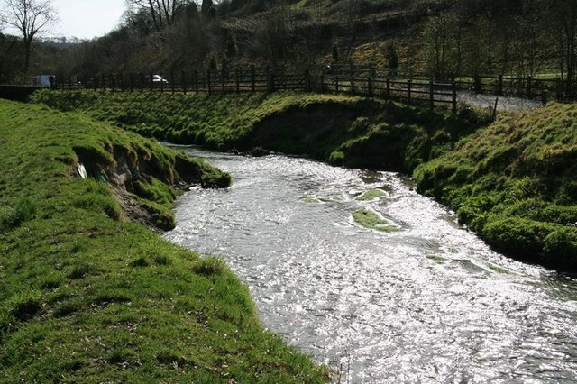
English: Erosion, St Austell River Serious erosion of both banks of the river at this point is starting to threaten the farm road on the right and the Pentewan Trail just out of shot on the left. Erosion is a constant problem on the White River and various remedies have been tried, with varying degrees of success. |
| Date | |
| Source | From geograph.org.uk |
| Author | John Gibson |
| Attribution (required by the license) | John Gibson / Erosion, St Austell River / |
| Camera location | | View this and other nearby images on: OpenStreetMap |
|---|
_heading:180.00&language=en)
| Object location | | View this and other nearby images on: OpenStreetMap |
|---|
_heading:180.00&language=en)
Licensing
edit

|
This image was taken from the Geograph project collection. See this photograph's page on the Geograph website for the photographer's contact details. The copyright on this image is owned by John Gibson and is licensed for reuse under the Creative Commons Attribution-ShareAlike 2.0 license.
|
This file is licensed under the Creative Commons Attribution-Share Alike 2.0 Generic license.
Attribution: John Gibson
- You are free:
- to share – to copy, distribute and transmit the work
- to remix – to adapt the work
- Under the following conditions:
- attribution – You must give appropriate credit, provide a link to the license, and indicate if changes were made. You may do so in any reasonable manner, but not in any way that suggests the licensor endorses you or your use.
- share alike – If you remix, transform, or build upon the material, you must distribute your contributions under the same or compatible license as the original.
File history
Click on a date/time to view the file as it appeared at that time.
| Date/Time | Thumbnail | Dimensions | User | Comment | |
|---|---|---|---|---|---|
| current | 06:31, 26 February 2011 | | 640 × 426 (102 KB) | GeographBot (talk | contribs) | == {{int:filedesc}} == {{Information |description={{en|1=Erosion, St Austell River Serious erosion of both banks of the river at this point is starting to threaten the farm road on the right and the Pentewan Trail just out of shot on the left. Erosion is |
You cannot overwrite this file.
File usage on Commons
There are no pages that use this file.