File:Eruption of Eyjafjallajökull Volcano, Iceland 2010-04-19.jpg

Size of this preview: 600 × 600 pixels. Other resolutions: 240 × 240 pixels | 480 × 480 pixels | 720 × 720 pixels.
Original file (720 × 720 pixels, file size: 166 KB, MIME type: image/jpeg)
Captions
Captions
Add a one-line explanation of what this file represents
Summary
edit
| Description |
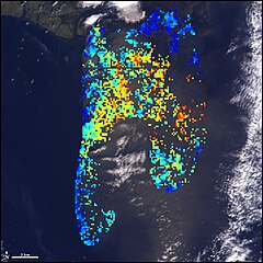
English: This satellite image shows the height of Eyjafjallajökull’s ash plume, superimposed with a natural-color view, on April 19, 2010. Color corresponds to height: bright blue indicates low elevation ash, green and yellow indicates ash at an elevation of about 3,000 meters (10,000 feet), and red indicates ash at or above 4,000 meters (13,000 feet). The image was acquired by the Multi-angle Imaging SpectroRadiometer (MISR) aboard NASA’s Terra spacecraft. |
| Date | |
| Source | http://earthobservatory.nasa.gov/NaturalHazards/view.php?id=43831&src=nha |
| Author | NASA image courtesy GSFC/LaRC/JPL, MISR Team. Caption by Robert Simmon. |
Licensing
edit
| This file is in the public domain in the United States because it was solely created by NASA. NASA copyright policy states that "NASA material is not protected by copyright unless noted". (See Template:PD-USGov, NASA copyright policy page or JPL Image Use Policy.) | ||
 |
Warnings:
|
File history
Click on a date/time to view the file as it appeared at that time.
| Date/Time | Thumbnail | Dimensions | User | Comment | |
|---|---|---|---|---|---|
| current | 11:33, 2 May 2010 | | 720 × 720 (166 KB) | Captain-tucker (talk | contribs) | {{Information |Description={{en|This satellite image shows the height of Eyjafjallajökull’s ash plume, superimposed with a natural-color view, on April 19, 2010. Color corresponds to height: bright blue indicates low elevation ash, green and yellow ind |
You cannot overwrite this file.
File usage on Commons
There are no pages that use this file.