File:Eruption of Raung Volcano (19684852442).jpg
Original file (1,200 × 1,200 pixels, file size: 1.57 MB, MIME type: image/jpeg)
Captions
Captions
Summary
edit.jpg&action=edit§ion=1)
| Description |
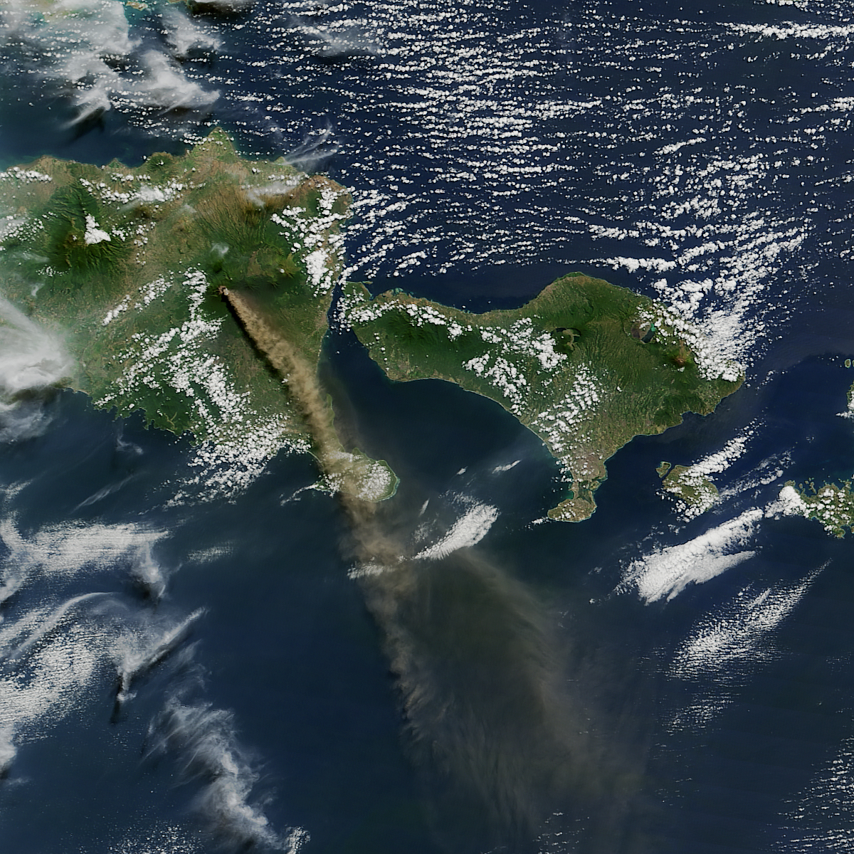
After several weeks of tectonic rumblings beneath the surface, one of the most active volcanoes in Indonesia began spewing ash plumes and lava into the skies over tropical Asia. At least 900 airplane flights into and out of Bali and other regional airports were cancelled due to concerns about the ash clouds, which wafted as high as 6 kilometers (20,000 feet) into the air. Volcanic ash can cause extensive damage and failures in jet engines. On July 12, 2015, the Moderate Resolution Imaging Spectroradiometer (MODIS) on NASA’s Aqua satellite captured this natural-color view of a plume of ash and volcanic gases trailing away from Mount Raung on the Indonesian island of Java. The image has a resolution of roughly 250 meters per pixel. Mount Raung is a stratovolcano that has erupted at least 13 times in the past 25 years, according to records kept by the Smithsonian Global Volcanism program. The summit stands 3,332 meters (10,932 feet) above sea level and is capped by steep caldera that is 3 kilometers (2 miles) in diameter. All of the known volcanic eruptions at Raung have occurred within that caldera. No evacuations were ordered for residents living near Raung, though authorities have urged people to wear face masks so as to not inhale ash. Download full resolution and read more at earthobservatory.nasa.gov/IOTD/view.php?id=86213&src=...
|
| Date | |
| Source | Eruption of Raung Volcano |
| Author | NASA's Earth Observatory |
| Camera location | | View this and other nearby images on: OpenStreetMap |
|---|
.jpg¶ms=-08.119157_N_0114.057655_E_globe:Earth_type:camera_source:Flickr_&language=en)
Licensing
edit.jpg&action=edit§ion=2)
- You are free:
- to share – to copy, distribute and transmit the work
- to remix – to adapt the work
- Under the following conditions:
- attribution – You must give appropriate credit, provide a link to the license, and indicate if changes were made. You may do so in any reasonable manner, but not in any way that suggests the licensor endorses you or your use.
| This image was originally posted to Flickr by NASA Earth Observatory at https://flickr.com/photos/68824346@N02/19684852442 (archive). It was reviewed on 13 December 2017 by FlickreviewR 2 and was confirmed to be licensed under the terms of the cc-by-2.0. |
File history
Click on a date/time to view the file as it appeared at that time.
| Date/Time | Thumbnail | Dimensions | User | Comment | |
|---|---|---|---|---|---|
| current | 05:49, 13 December 2017 | | 1,200 × 1,200 (1.57 MB) | A1Cafel (talk | contribs) | Transferred from Flickr via Flickr2Commons |
You cannot overwrite this file.
File usage on Commons
There are no pages that use this file.
.jpg&oldid=893941240)