File:Erzgebirge Naturraum map de.png

Size of this preview: 800 × 490 pixels. Other resolutions: 320 × 196 pixels | 640 × 392 pixels | 1,079 × 661 pixels.
Original file (1,079 × 661 pixels, file size: 1.22 MB, MIME type: image/png)
Captions
Captions
Add a one-line explanation of what this file represents
Summary
edit
| Description |
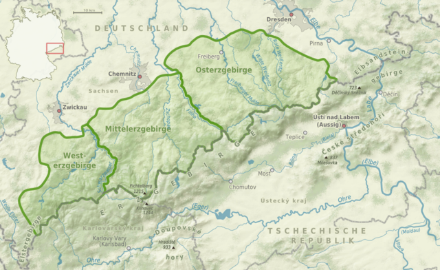
Deutsch: Karte der Naturräume im deutschen Teil des Erzgebirges
English: Natural regions in the German part of the Ore Mountains |
| Date | |
| Source |
own work, using
|
| Author | Alexrk2 |
| Permission (Reusing this file) |
All OpenStreetMap data and maps are Creative Commons "CC-BY-SA 2.0" licensed |

|
This map has been made or improved in the German Kartenwerkstatt (Map Lab). You can propose maps to improve as well.
|
Licensing
edit
I, the copyright holder of this work, hereby publish it under the following license:
This file is licensed under the Creative Commons Attribution-Share Alike 3.0 Unported license.
- You are free:
- to share – to copy, distribute and transmit the work
- to remix – to adapt the work
- Under the following conditions:
- attribution – You must give appropriate credit, provide a link to the license, and indicate if changes were made. You may do so in any reasonable manner, but not in any way that suggests the licensor endorses you or your use.
- share alike – If you remix, transform, or build upon the material, you must distribute your contributions under the same or compatible license as the original.
File history
Click on a date/time to view the file as it appeared at that time.
| Date/Time | Thumbnail | Dimensions | User | Comment | |
|---|---|---|---|---|---|
| current | 16:38, 21 December 2010 | | 1,079 × 661 (1.22 MB) | Alexrk2 (talk | contribs) | Chemnitz (Fluss) korrigiert |
| 16:02, 19 May 2010 |  | 1,079 × 661 (1.22 MB) | Alexrk2 (talk | contribs) | Pressnitz/Zschopau | |
| 16:39, 17 December 2009 |  | 1,079 × 661 (1.22 MB) | Alexrk2 (talk | contribs) | == {{int:filedesc}} == {{Information |Description={{de|Karte Naturräume im Erzgebirge}} {{en|Natural regions of Ore Mountains}} |Source=|Source=own work, using * VMAP0 * SRTM3 * Geonames.org * [http://www.openstreetmap.org Openstreetmap] data * [[:File:G |
You cannot overwrite this file.
File usage on Commons
There are no pages that use this file.
File usage on other wikis
The following other wikis use this file:
- Usage on de.wikipedia.org
- Usage on de.wikivoyage.org
- Usage on en.wikipedia.org
- Usage on es.wikipedia.org
- Usage on zh.wikipedia.org