File:Esterhazypark-Bunker Wien Dez2006.jpg

Size of this preview: 387 × 599 pixels. Other resolutions: 155 × 240 pixels | 310 × 480 pixels | 496 × 768 pixels | 661 × 1,024 pixels | 1,539 × 2,383 pixels.
Original file (1,539 × 2,383 pixels, file size: 639 KB, MIME type: image/jpeg)
Captions
Captions
Add a one-line explanation of what this file represents
| Description |
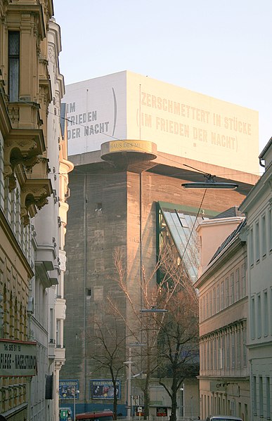
Deutsch: Der von Oktober 1943 bis Juli 1944 errichtete Leitturm im Esterhazypark (VI. Wiener Gemeindebezirk Mariahilf/Wien); im oberesten Abschnitt, die von dem US-amerikanischen Konzeptkünstler Lawrence Weiner 1991 gestaltete Aufschrift: Zerschmettert in Stücke im Frieden der Nacht/Smashed to pieces in the still of the night / English: The flak-tower in the Esterhazypark in Vienna, built from october 1943 to july 1944; visible at the top part is the inscription attached by the conceptual artist Lawrence Weiner (USA) in 1991: Smashed to pieces in the still of the night/Zerschmettert in Stücke im Frieden der Nacht |
||||||||
| Date | |||||||||
| Source | Own work | ||||||||
| Author | Manfred Werner - User:Tsui | ||||||||
| Permission (Reusing this file) |
|

| Camera location | | View this and other nearby images on: OpenStreetMap |
|---|
File history
Click on a date/time to view the file as it appeared at that time.
| Date/Time | Thumbnail | Dimensions | User | Comment | |
|---|---|---|---|---|---|
| current | 21:34, 27 December 2006 | | 1,539 × 2,383 (639 KB) | Tsui (talk | contribs) | {{Information |Description= '''de:''' Der von Oktober 1943 bis Juli 1944 errichtete Leitturm im Esterhazypark (VI. Wiener Gemeindebezirk Mariahilf/Wien); im oberesten Abschnitt, die von dem US-amerikanischen Konzeptkünstler Lawrence Weiner 1991 g |
You cannot overwrite this file.
File usage on Commons
The following 2 pages use this file:
File usage on other wikis
The following other wikis use this file:
- Usage on en.wikipedia.org
- Usage on fr.wikipedia.org
- Usage on he.wikipedia.org
- Usage on it.wikipedia.org
- Usage on sv.wikipedia.org