File:Esteros del Iberá, Argentina.jpg
Size of this preview: 800 × 454 pixels. Other resolutions: 320 × 181 pixels | 640 × 363 pixels | 1,024 × 581 pixels | 1,280 × 726 pixels | 2,560 × 1,452 pixels | 4,529 × 2,568 pixels.
Original file (4,529 × 2,568 pixels, file size: 6.24 MB, MIME type: image/jpeg)
Captions
Captions
Add a one-line explanation of what this file represents
Summary
edit
| Description |
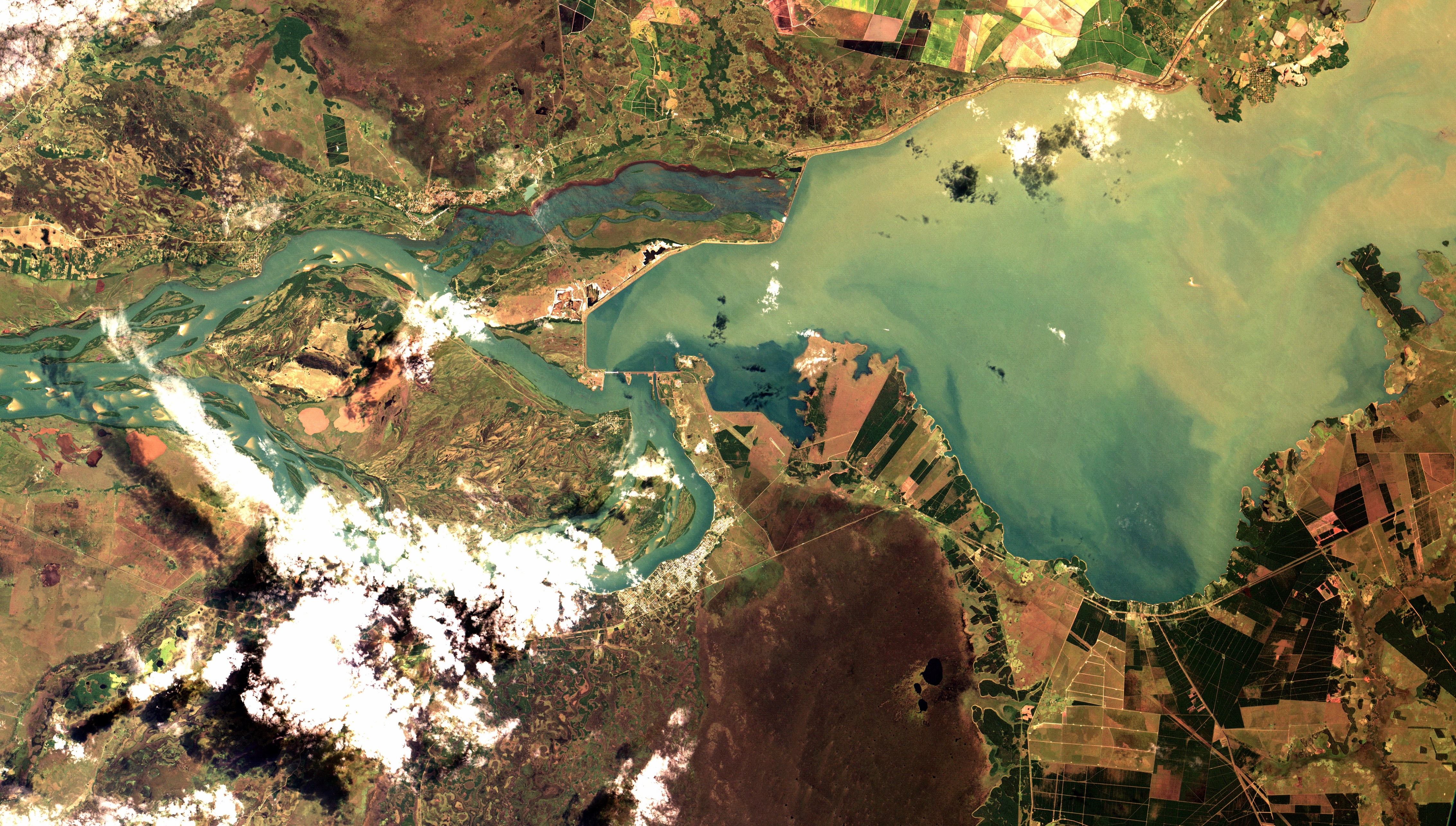
Português: Zona úmida do Iberá, Argentina, segunda maior no mundo depois do Pantanal no Brasil e um dos mais importantes reservatórios de água fresca na América. Mistura de pântanos, lagos, lamaçais e cursos d'água, aparece em marrom, às vezes com faixas verdes de floresta ripária, com a superfície da água exposta em preto na parte central inferior e esquerda da imagem. Área urbana de Ituzanga em salpicado branco, às margens do Rio Paraná em azul e verde claro. No canto superior esq. a represa da UHE de Jaciretá, na fronteira com o Uruguai. Reflorestamentos em verde escuro e pastagens em verde claro, à margem do reservatório / Argentina´s Iberá wetlands, World´s second largest after Brazilian Pantanal and one of America´s most important freshwater reservoir. Mix of marshes, lakes, mires and streams, appears in brown, sometimes with green ripary forest strips, with exposed water surface in black at image lower and left center area. Ituzanga urban area, by Paraná River in blue and light green, appears in satpepper. At image top left is Yaciretá hidroelectric, at Uruguay border. By the reservoir, reforestation in dark green and pastures in light green.
Imagem / Image CBERS4 MUX Esteros del Iberá, Argentina Coordenadas do centro da imagem / Image center: 27°43'45.8"S 56°35'30.1"W Data / Date: 21-03-2019 / 2019-21-03 RGB 765 (cor verdadeira / true color) Cena / Scene: 164 / 131 Autor / Author: Oton Barros (DSR/OBT/INPE) Imagem em HD / HD Image Visite-nos / Visit us: www.dsr.inpe.br |
| Date | |
| Source | https://www.flickr.com/photos/153282474@N02/33566994418/ |
| Author | Coordenação-Geral de Observação da Terra/INPE |
Licensing
edit
This file is licensed under the Creative Commons Attribution-Share Alike 2.0 Generic license.
- You are free:
- to share – to copy, distribute and transmit the work
- to remix – to adapt the work
- Under the following conditions:
- attribution – You must give appropriate credit, provide a link to the license, and indicate if changes were made. You may do so in any reasonable manner, but not in any way that suggests the licensor endorses you or your use.
- share alike – If you remix, transform, or build upon the material, you must distribute your contributions under the same or compatible license as the original.
| This image was originally posted to Flickr by Coordenação-Geral de Observação da Terra/INPE at https://flickr.com/photos/153282474@N02/33566994418. It was reviewed on 9 April 2020 by FlickreviewR 2 and was confirmed to be licensed under the terms of the cc-by-sa-2.0. |
File history
Click on a date/time to view the file as it appeared at that time.
| Date/Time | Thumbnail | Dimensions | User | Comment | |
|---|---|---|---|---|---|
| current | 10:13, 9 April 2020 | | 4,529 × 2,568 (6.24 MB) | Jo-Jo Eumerus (talk | contribs) | Uploaded a work by Coordenação-Geral de Observação da Terra/INPE from https://www.flickr.com/photos/153282474@N02/33566994418/ with UploadWizard |
You cannot overwrite this file.
File usage on Commons
The following page uses this file:
- File:Esteros del Iberá, Argentina (33566994418).jpg (file redirect)
.jpg&redirect=no)