File:Ethiopia population density map.jpg
Size of this preview: 679 × 599 pixels. Other resolutions: 272 × 240 pixels | 544 × 480 pixels | 870 × 768 pixels | 1,056 × 932 pixels.
Original file (1,056 × 932 pixels, file size: 193 KB, MIME type: image/jpeg)
Captions
Captions
Add a one-line explanation of what this file represents
| Description |
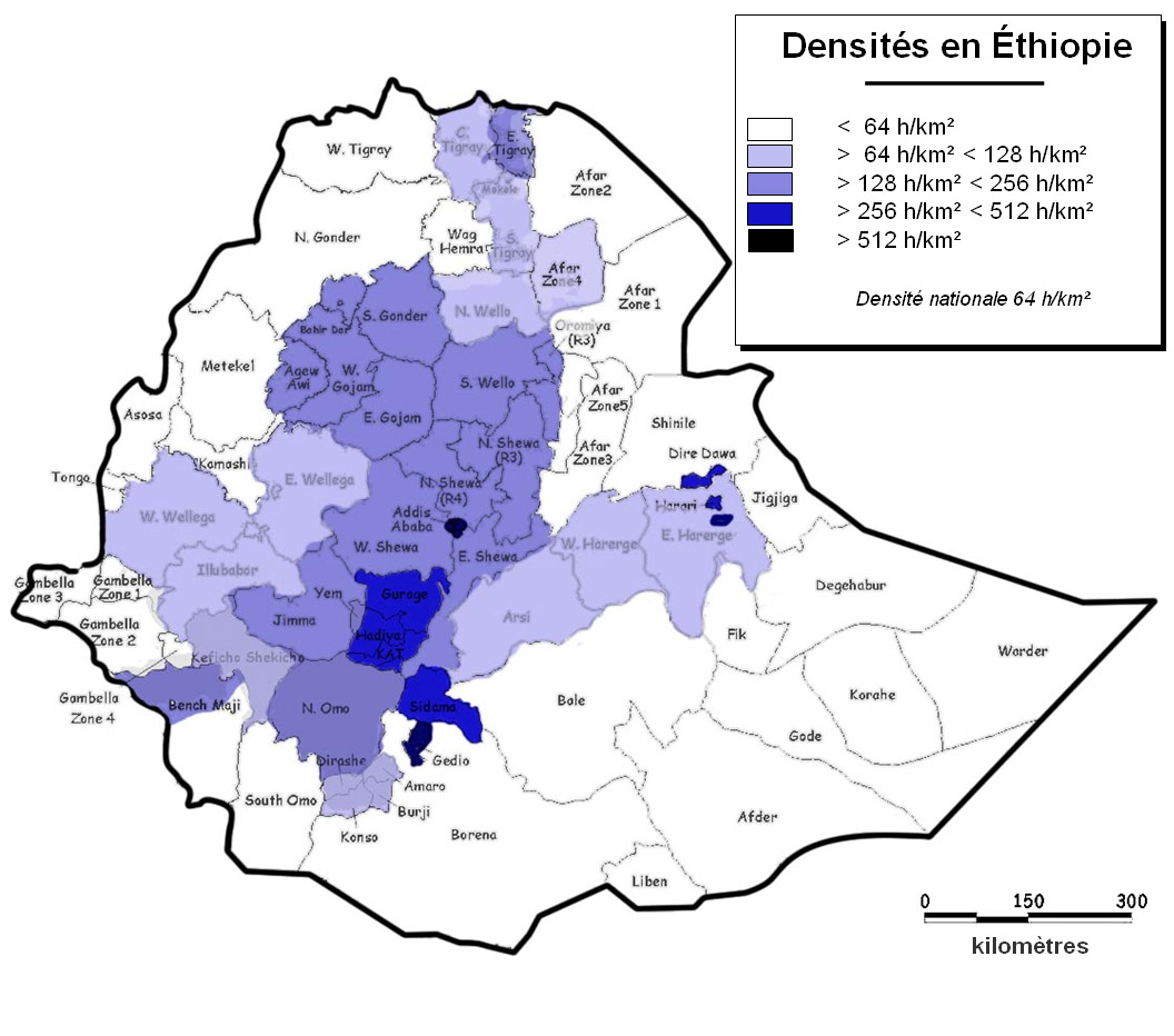
Français : Densité de population en Éthiopie (d'après Alain Gascon, CSA 2004)
English: Population denbsity in Ethiopie (2004) |
| Date | (UTC) |
| Source | |
| Author |
|
| This is a retouched picture, which means that it has been digitally altered from its original version. The original can be viewed here: Ethiopia zone region.jpg:
|
I, the copyright holder of this work, hereby publish it under the following license:

|
The copyright holder of this work allows anyone to use it for any purpose including unrestricted redistribution, commercial use, and modification.
Usage notes:
|
Original upload log edit
This image is a derivative work of the following images:
- File:Ethiopia_zone_region.jpg licensed with Copyrighted free use
- 2007-01-03T01:53:29Z Classof2006smr 1246x848 (100933 Bytes) Map of regions and zones in Ethiopia. Used with permission from USAID/Ethiopia.
Uploaded with derivativeFX
File history
Click on a date/time to view the file as it appeared at that time.
| Date/Time | Thumbnail | Dimensions | User | Comment | |
|---|---|---|---|---|---|
| current | 16:03, 6 February 2010 | | 1,056 × 932 (193 KB) | Zheim~commonswiki (talk | contribs) | {{Information |Description={{fr}} Densité de population en Éthiopie (d'après Alain Gascon, CSA 2004) {{en}} Population denbsity in Ethiopie (2004) |Source=*File:Ethiopia_zone_region.jpg |Date=2010-02-06 16:01 (UTC) |Author=*[[:File:Ethiopia_zone_ |
You cannot overwrite this file.
File usage on Commons
There are no pages that use this file.
File usage on other wikis
The following other wikis use this file:
- Usage on fr.wikipedia.org