File:Europe biogeography regions de.svg

Size of this PNG preview of this SVG file: 800 × 559 pixels. Other resolutions: 320 × 223 pixels | 640 × 447 pixels | 1,024 × 715 pixels | 1,280 × 894 pixels | 2,560 × 1,788 pixels | 3,737 × 2,610 pixels.
Original file (SVG file, nominally 3,737 × 2,610 pixels, file size: 1.31 MB)
Captions
Captions
Add a one-line explanation of what this file represents
| Description |
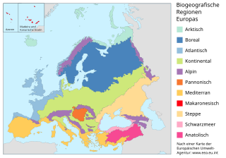
Deutsch: Karte der biogeografischen Regionen Europas.
English: Map of the biogeographic regions of Europe, showing only biogeographical region boundaries, not national borders. Legend in English. SVG format. |
||
| Date | (UTC) | ||
| Source | |||
| Author |
|
||
| SVG development | This W3C-invalid map was created with Adobe Illustrator, and with Inkscape.
|
I, the copyright holder of this work, hereby publish it under the following license:
This file is licensed under the Creative Commons Attribution-Share Alike 3.0 Unported license.
- You are free:
- to share – to copy, distribute and transmit the work
- to remix – to adapt the work
- Under the following conditions:
- attribution – You must give appropriate credit, provide a link to the license, and indicate if changes were made. You may do so in any reasonable manner, but not in any way that suggests the licensor endorses you or your use.
- share alike – If you remix, transform, or build upon the material, you must distribute your contributions under the same or compatible license as the original.
Original upload log edit
This image is a derivative work of the following images:
- File:Europe biogeography regions en.svg licensed with Cc-by-sa-3.0
- 2006-05-23T10:50:03Z Tintazul 3600x2610 (761530 Bytes) {{Tintazul| |Description=Map of the biogeographic regions of Europe, showing only biogeographical region boundaries, not national borders. Legend in English. SVG format. |Date=20 May 2006 |Source=[[:Image:Europe biogeography
Uploaded with derivativeFX
File history
Click on a date/time to view the file as it appeared at that time.
| Date/Time | Thumbnail | Dimensions | User | Comment | |
|---|---|---|---|---|---|
| current | 22:54, 28 August 2010 | | 3,737 × 2,610 (1.31 MB) | Furfur (talk | contribs) | kleine Änderung |
| 22:52, 28 August 2010 |  | 3,737 × 2,610 (1.31 MB) | Furfur (talk | contribs) | kosmetische Änderungen | |
| 17:27, 15 May 2010 |  | 3,600 × 2,610 (451 KB) | Furfur (talk | contribs) | {{Information |Description={{de|Karte der biogeografischen Regionen Europas.}} {{en|Map of the biogeographic regions of Europe, showing only biogeographical region boundaries, not national borders. Legend in English. SVG format. |Date=2006-05-20}} |Source |
You cannot overwrite this file.
File usage on Commons
The following page uses this file:
File usage on other wikis
The following other wikis use this file:
- Usage on bs.wikipedia.org
- Usage on de.wikipedia.org
- Usage on de.wikibooks.org
- Usage on la.wikipedia.org
- Usage on nds.wikipedia.org