File:Europe large topographic location map.png
Size of this preview: 771 × 600 pixels. Other resolutions: 309 × 240 pixels | 617 × 480 pixels | 987 × 768 pixels | 1,280 × 996 pixels | 2,334 × 1,816 pixels.
Original file (2,334 × 1,816 pixels, file size: 1.19 MB, MIME type: image/png)
Captions
Captions
Add a one-line explanation of what this file represents
Summary
edit
{{Information
|description=
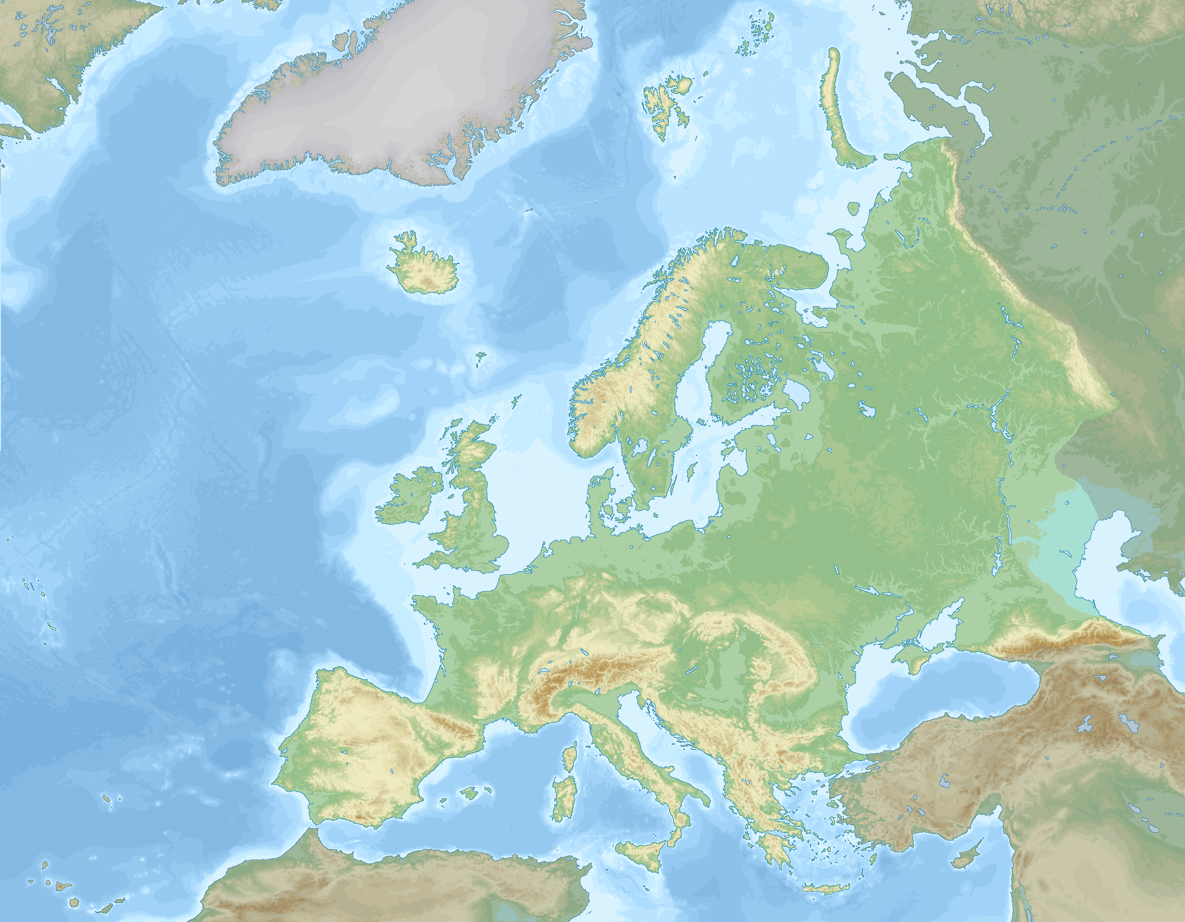
English: Location map of Europe stretching to the Canary Islands, Azores, Franz Joseph land and the entire Caucasus. A definition of Europe as bounded by the Caucasus mountains, Ural river and Ural mountains is shown.
Elevations (in Europe):
negative
0 to 100 m
100 to 200 m
200 to 300 m
300 to 400 m
400 to 500 m
500 to 600 m
600 to 800 m
800 to 1000 m
1000 to 1200 m
1200 to 1600 m
1600 to 2000 m
2000 to 2500 m
2500 to 3000 m
3000 to 3500 m
3500 to 4000 m
above 4000 m
Sea depths:
0 to 100 m
100 to 200 m
200 to 500 m
500 to 1000 m
1000 to 2000 m
2000 to 3000 m
3000 to 4000 m
4000 to 5000 m
below 5000 m
Data source: GEBCO 2022Map Info
edit
| Projection: | Stereographic |
|---|---|
| Projection center: | North Pole |
| Vertical meridian: | 15.000° E |
| Position of vertical meridian: | 55.4113 % of image width from left edge |
| Position of pole: | 8.9207 % of image height above top edge |
| Scale at pole: | 1.8011 % of image height ( = 1.4013 % of image width) per degree |
| x (%)= | 55.4113 + 160.5827*tan(pi*(90 - $1)/360)*sin(pi*($2 - 15)/180)
|
|---|---|
| y (%)= | -8.9207 + 206.3877*tan(pi*(90 - $1)/360)*cos(pi*($2 - 15)/180)
|
| $1: | latitude in degrees (positive for all locations on map). |
| $2: | longitude in degrees (positive or negative). |
| x (%): | x coordinate expressed as percentage of image width (measured from left edge). |
| y (%): | y coordinate expressed as percentage of image height (measured from top edge). |
Licensing
edit
I, the copyright holder of this work, hereby publish it under the following license:
This file is licensed under the Creative Commons Attribution-Share Alike 4.0 International license.
- You are free:
- to share – to copy, distribute and transmit the work
- to remix – to adapt the work
- Under the following conditions:
- attribution – You must give appropriate credit, provide a link to the license, and indicate if changes were made. You may do so in any reasonable manner, but not in any way that suggests the licensor endorses you or your use.
- share alike – If you remix, transform, or build upon the material, you must distribute your contributions under the same or compatible license as the original.
File history
Click on a date/time to view the file as it appeared at that time.
| Date/Time | Thumbnail | Dimensions | User | Comment | |
|---|---|---|---|---|---|
| current | 20:03, 5 September 2023 | | 2,334 × 1,816 (1.19 MB) | GrandEscogriffe (talk | contribs) | darker non-european lands; coastlines in blue |
| 18:32, 1 December 2022 |  | 2,334 × 1,816 (1.17 MB) | GrandEscogriffe (talk | contribs) | Uploaded own work with UploadWizard |
You cannot overwrite this file.
File usage on Commons
The following 3 pages use this file:
File usage on other wikis
The following other wikis use this file:
- Usage on en.wikipedia.org
- Usage on fr.wikipedia.org
- Mer de Barents
- Mer Égée
- Dardanelles
- Nouvelle-Zemble
- Île Jan Mayen
- Rockall
- Île aux Ours
- Mer de Kara
- Liste des départements de France par altitude
- Mer Blanche
- Kolbeinsey
- Mer de Norvège
- Mer du Groenland
- Terre François-Joseph
- An Tiaracht
- Gavdos
- Cabo da Roca
- Détroit de Danemark
- Liste des provinces et territoires d'outre-mer des Pays-Bas par point culminant
- Canal de Sicile
- Capelinhos
- Cap Fligely
- Mer d'Irminger
- Baie Baïdaratskaïa
- Liste des régions et provinces d'Italie par altitude
- Mer Caspienne
- Svalbard
- Liste des cantons de Suisse par altitude
- Cap Jelania
- Bjargtangar
- Rossøya
- Mer de Sicile
- Pointe de Tarifa
- Île Victoria (Russie)
- Cap Flissingski
- Îlot de Monchique
- Vatnahverfi
- Fosse Calypso
- Liste des comtés d'Irlande par point culminant
- Liste des Länder d'Allemagne par point culminant
- Modèle:Palette Liste des points culminants des pays d'Europe
- Liste des entités de Belgique par point culminant
- Modèle:Géolocalisation/Europe 2
- Wikipédia:Atelier graphique/Cartes/Archives/décembre 2022
- Liste des provinces d'Espagne par point culminant
- Liste des fylker de Norvège par point culminant
- Liste des Länder d'Autriche par point culminant
- Liste des régions de Finlande par point culminant
View more global usage of this file.