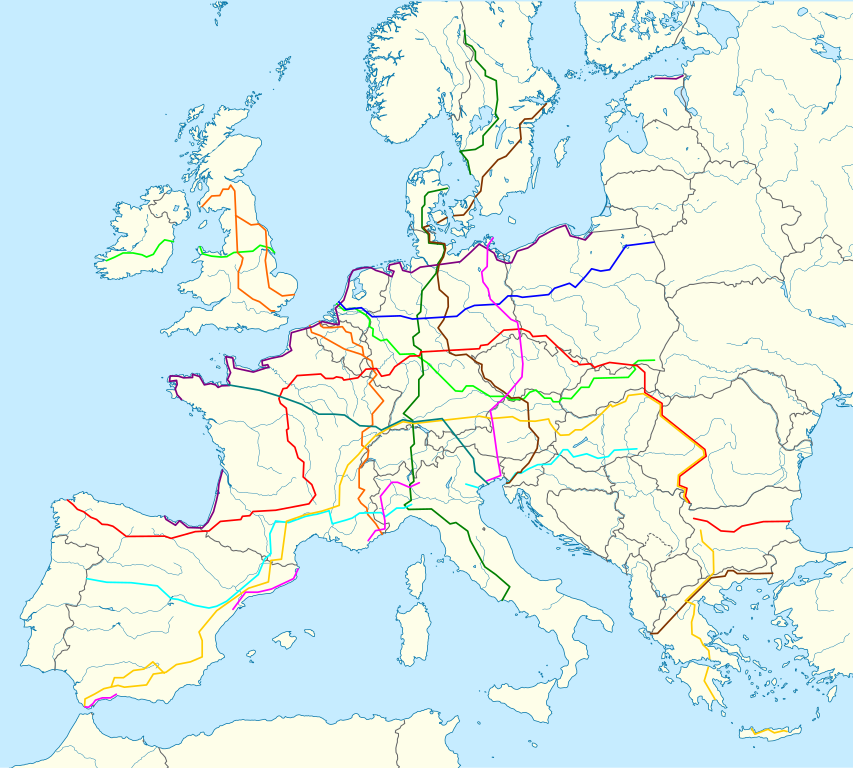
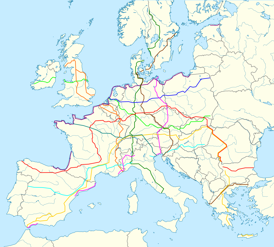
File:European long-distance paths.svg

Size of this PNG preview of this SVG file: 666 × 599 pixels. Other resolutions: 267 × 240 pixels | 533 × 480 pixels | 853 × 768 pixels | 1,138 × 1,024 pixels | 2,276 × 2,048 pixels | 1,000 × 900 pixels.
Original file (SVG file, nominally 1,000 × 900 pixels, file size: 1.65 MB)
Captions
Captions
Add a one-line explanation of what this file represents
Summary
edit
| Description |
Deutsch: Karte europäischer Fernwanderwege; Politisch mit Staatsgrenzen, Inlandgewässer; Flächentreue Azimutalprojektion English: Map of europeanlong distance paths; Political with state boundaries, inland water; Lambert azimuthal equal-area projection
|
| Date | (UTC) |
| Source |
This file was derived from: |
| Author |
|
This W3C-unspecified vector image was created with Inkscape .
Licensing
edit
I, the copyright holder of this work, hereby publish it under the following license:
This file is licensed under the Creative Commons Attribution-Share Alike 3.0 Unported license.
- You are free:
- to share – to copy, distribute and transmit the work
- to remix – to adapt the work
- Under the following conditions:
- attribution – You must give appropriate credit, provide a link to the license, and indicate if changes were made. You may do so in any reasonable manner, but not in any way that suggests the licensor endorses you or your use.
- share alike – If you remix, transform, or build upon the material, you must distribute your contributions under the same or compatible license as the original.
Original upload log
edit
This image is a derivative work of the following images:
- File:Europe_laea_location_map.svg licensed with Cc-by-sa-3.0
- 2012-08-20T22:57:00Z McZusatz 1401x1198 (2313185 Bytes) Reverted to version as of 19:40, 10 March 2010 (...thumb fixed?)
- 2012-08-20T22:56:21Z McZusatz 1401x1198 (1521812 Bytes) Reverted to version as of 18:44, 10 March 2010 (fixing thumb...)
- 2010-03-10T19:40:39Z Alexrk2 1401x1198 (2313185 Bytes) +San Marino, enh. coastline & countries
- 2010-03-10T18:44:00Z Alexrk2 1401x1198 (1521812 Bytes) == Summary == {{Information |Description= {{de|Positionskarte [[:de:Europa|Europa]]; Politisch mit Staatsgrenzen, Inlandgewässer; Flächentreue Azimutalprojektion}} {{en|Location map [[:en:Europe|Europe]]; Political with sta
Uploaded with derivativeFX
File history
Click on a date/time to view the file as it appeared at that time.
| Date/Time | Thumbnail | Dimensions | User | Comment | |
|---|---|---|---|---|---|
| current | 13:30, 10 May 2013 | | 1,000 × 900 (1.65 MB) | Pyfisch (talk | contribs) | bugs fixed reported at User_talk:Pyfisch#Grafik European_long-distance_paths.svg. |
| 12:02, 2 February 2013 |  | 1,000 × 900 (1.64 MB) | Pyfisch (talk | contribs) | Missing path (E5) added. | |
| 11:20, 2 February 2013 |  | 1,000 × 900 (1.64 MB) | Pyfisch (talk | contribs) | == {{int:filedesc}} == {{Information |Description={{de|Positionskarte Europa; Politisch mit Staatsgrenzen, Inlandgewässer; Flächentreue Azimutalprojektion}} {{en|Location map Europe; Political with state boundaries, inla... |
You cannot overwrite this file.
File usage on Commons
The following 16 pages use this file:
- File:Euro-Map-all.png
- File:Map of the European Long Distance Path E1.png
- File:Map of the European Long Distance Path E10.png
- File:Map of the European Long Distance Path E11.png
- File:Map of the European Long Distance Path E12.png
- File:Map of the European Long Distance Path E2.png
- File:Map of the European Long Distance Path E3.png
- File:Map of the European Long Distance Path E4.png
- File:Map of the European Long Distance Path E5.png
- File:Map of the European Long Distance Path E6.png
- File:Map of the European Long Distance Path E7.png
- File:Map of the European Long Distance Path E8.png
- File:Map of the European Long Distance Path E9.png
- File:Map of the European Long Distance Paths.png
- File:Map of the European long distance paths.svg
- File:Mapa senderos Europa.png
File usage on other wikis
The following other wikis use this file:
- Usage on de.wikipedia.org
- Usage on de.wikivoyage.org
- Usage on sv.wikipedia.org