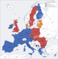
File:European union emu map fr.png

Original file (1,165 × 1,200 pixels, file size: 934 KB, MIME type: image/png)
Captions
Captions
This file requires updating because: brexit, Romania and Bulgaria applied for ERM II In doing so, you could add a timestamp to the file.
|
Summary
edit| DescriptionEuropean union emu map fr.png |
Français : union économique et monétaire, carte fr |
| Date | |
| Source | carte créée par l'utilisateur, à partir des Generic Mapping Tools et de ETOPO2 |
| Author | San Jose |
| Other versions | anglais, allemand, sans texte |
Licensing
editThe map has been created with the Generic Mapping Tools: https://www.generic-mapping-tools.org/ using one or more of these public-domain datasets for the relief:
বাংলা ∙ English ∙ español ∙ français ∙ italiano ∙ 日本語 ∙ македонски ∙ sicilianu ∙ 中文(简体) ∙ 中文(繁體) ∙ +/− |

|
Permission is granted to copy, distribute and/or modify this document under the terms of the GNU Free Documentation License, Version 1.2 or any later version published by the Free Software Foundation; with no Invariant Sections, no Front-Cover Texts, and no Back-Cover Texts. A copy of the license is included in the section entitled GNU Free Documentation License.http://www.gnu.org/copyleft/fdl.htmlGFDLGNU Free Documentation Licensetruetrue |
| This file is licensed under the Creative Commons Attribution-Share Alike 3.0 Unported license. | ||
| ||
| This licensing tag was added to this file as part of the GFDL licensing update.http://creativecommons.org/licenses/by-sa/3.0/CC BY-SA 3.0Creative Commons Attribution-Share Alike 3.0truetrue |
Datasource
edit| Code | ETOPO2 | ||||
| Title | Global 2 Arc-minute Ocean Depth and Land Elevation | ||||
| DescriptionEuropean union emu map fr.png |
English: Global elevation and bathymetry on 2 arc-minute grid from the National Geophysical Data Center (NGDC). This dataset was original published in September 2001 and was revised to include correction to Caspian Sea area in April 2006. It contains improvements that include the blending of satellite altimetry with ocean soundings and new land elevation data from the Global Land One-km Base Elevations (GLOBE) project.
|
||||
| Date | 2001 | ||||
| Source | National Geophysical Data Center, NESDIS, NOAA, U.S. Department of Commerce. 2001. ETOPO2, Global 2 Arc-minute Ocean Depth and Land Elevation from the US National Geophysical Data Center (NGDC). Research Data Archive at the National Center for Atmospheric Research, Computational and Information Systems Laboratory. | ||||
| Author | National Geophysical Data Center, NESDIS, NOAA, U.S. Department of Commerce. | ||||
| ⧼wm-license-information-license⧽ (Reusing this file) |
|
File history
Click on a date/time to view the file as it appeared at that time.
| Date/Time | Thumbnail | Dimensions | User | Comment | |
|---|---|---|---|---|---|
| current | 09:03, 2 January 2015 |  | 1,165 × 1,200 (934 KB) | Richardw (talk | contribs) | Litouwen gebruikt sinds 1 januari 2015 euro's Lituanie utilise l'euro depuis le 1er janvier 2015 |
| 08:54, 1 January 2014 |  | 1,165 × 1,200 (427 KB) | France05alpes (talk | contribs) | Reverted to version as of 13:34, 13 December 2013 | |
| 20:04, 15 December 2013 |  | 1,165 × 1,200 (887 KB) | Atoine85 (talk | contribs) | Trop tôt | |
| 13:34, 13 December 2013 |  | 1,165 × 1,200 (427 KB) | San Jose (talk | contribs) | update | |
| 16:46, 12 September 2013 |  | 1,165 × 1,200 (887 KB) | Masterdeis (talk | contribs) | + Slovenia in the EMU | |
| 15:26, 13 July 2013 |  | 1,165 × 1,200 (883 KB) | Masterdeis (talk | contribs) | + Croatia | |
| 08:49, 31 December 2010 |  | 1,165 × 1,200 (422 KB) | San Jose (talk | contribs) | update | |
| 13:12, 27 December 2008 |  | 1,165 × 1,200 (428 KB) | San Jose (talk | contribs) | update | |
| 09:47, 12 June 2008 |  | 1,165 × 1,200 (422 KB) | San Jose (talk | contribs) | update | |
| 15:41, 26 December 2007 |  | 1,165 × 1,200 (417 KB) | San Jose (talk | contribs) | update |
You cannot overwrite this file.
File usage on Commons
The following 3 pages use this file:
File usage on other wikis
The following other wikis use this file:
- Usage on bg.wikipedia.org
- Usage on de.wikipedia.org
- Usage on fr.wikipedia.org
- Usage on fr.wikinews.org
- Usage on fr.wikiversity.org
- Usage on kab.wikipedia.org
Metadata
This file contains additional information such as Exif metadata which may have been added by the digital camera, scanner, or software program used to create or digitize it. If the file has been modified from its original state, some details such as the timestamp may not fully reflect those of the original file. The timestamp is only as accurate as the clock in the camera, and it may be completely wrong.
| Horizontal resolution | 37.8 dpc |
|---|---|
| Vertical resolution | 37.8 dpc |
| Software used |
