File:Expl2289 - Flickr - NOAA Photo Library.jpg
Size of this preview: 800 × 598 pixels. Other resolutions: 320 × 239 pixels | 640 × 478 pixels | 1,024 × 765 pixels | 1,280 × 956 pixels | 1,790 × 1,337 pixels.
Original file (1,790 × 1,337 pixels, file size: 424 KB, MIME type: image/jpeg)
Captions
Captions
Add a one-line explanation of what this file represents
Summary
edit
| Description |
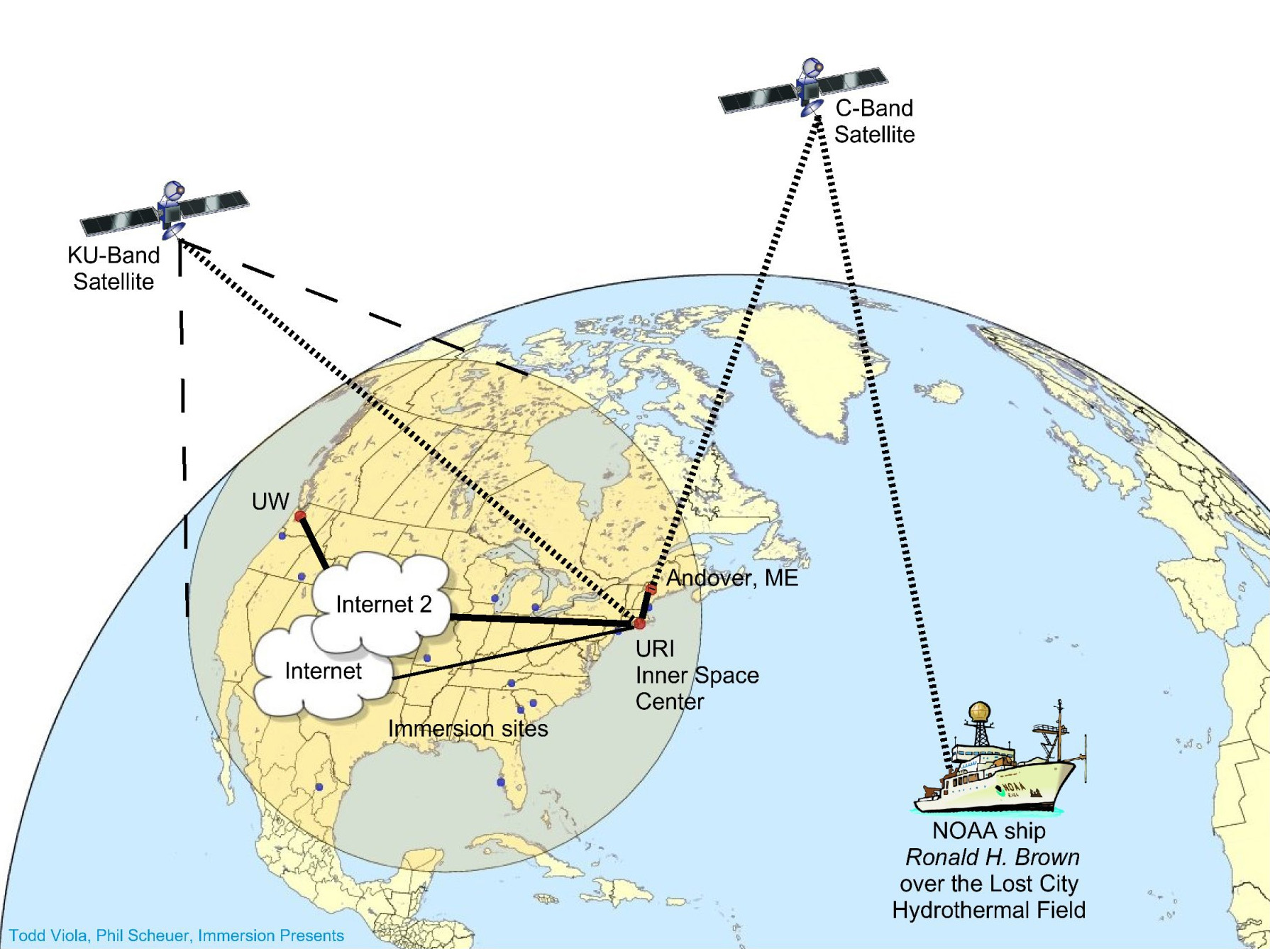
English: Diagram of communication system used during Lost City Expedition. This was the first NOAA expedition to use telepresence technology to transmit data to scientists at remote sites for observation, identification, and partaking in expedition decision-making process. 2005 July. Atlantic Ocean, Mid-Atlantic Ridge. |
| Date | |
| Source | NOAA Photo Library: expl2289 |
| Author | Todd Viola, Phil Scheuer, Immersion Presents; NOAA/OAR/OER; The Lost City 2005 Expedition. |
Licensing
edit
This file is licensed under the Creative Commons Attribution 2.0 Generic license.
- You are free:
- to share – to copy, distribute and transmit the work
- to remix – to adapt the work
- Under the following conditions:
- attribution – You must give appropriate credit, provide a link to the license, and indicate if changes were made. You may do so in any reasonable manner, but not in any way that suggests the licensor endorses you or your use.
| This image was originally posted to Flickr by NOAA Photo Library at https://www.flickr.com/photos/51647007@N08/5277866278. It was reviewed on 30 December 2012 by FlickreviewR and was confirmed to be licensed under the terms of the cc-by-2.0. |
This image is in the public domain because it contains materials that originally came from the U.S. National Oceanic and Atmospheric Administration, taken or made as part of an employee's official duties.
|
File history
Click on a date/time to view the file as it appeared at that time.
| Date/Time | Thumbnail | Dimensions | User | Comment | |
|---|---|---|---|---|---|
| current | 02:09, 3 December 2019 | | 1,790 × 1,337 (424 KB) | Ras67 (talk | contribs) | cropped |
| 09:35, 6 January 2012 |  | 1,800 × 1,347 (302 KB) | Kobac (talk | contribs) | {{Information |Description=Diagram of communication system used during Lost City Expedition. This was the first NOAA expedition to use telepresence technology to transmit data to scientists at remote sites for observation, identification, and partaking in |
You cannot overwrite this file.
File usage on Commons
There are no pages that use this file.
File usage on other wikis
The following other wikis use this file:
- Usage on id.wikipedia.org