File:Explorations and Surveys South of Central Pacific Railroad - Preliminary Topographical Map - DPLA - 36a2e57fa58598b08434ca8799846d11.jpg

Size of this preview: 462 × 599 pixels. Other resolutions: 185 × 240 pixels | 370 × 480 pixels | 592 × 768 pixels | 790 × 1,024 pixels | 1,579 × 2,048 pixels | 9,000 × 11,669 pixels.
Original file (9,000 × 11,669 pixels, file size: 6.61 MB, MIME type: image/jpeg)
Captions
Captions
Add a one-line explanation of what this file represents
Summary
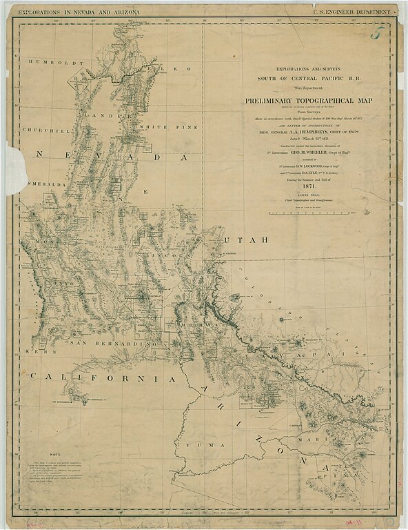
edit| Explorations and Surveys South of Central Pacific Railroad - Preliminary Topographical Map
( |
||||||||||||||
|---|---|---|---|---|---|---|---|---|---|---|---|---|---|---|
| Creator | War Department. Office of the Chief of Engineers. 1818-9/18/1947 | |||||||||||||
| Title |
Explorations and Surveys South of Central Pacific Railroad - Preliminary Topographical Map |
|||||||||||||
| Date | 1871 | |||||||||||||
| Collection |
|
|||||||||||||
| Source/Photographer |
|
|||||||||||||
| Permission (Reusing this file) |
|
|||||||||||||
| Standardized rights statement |
|
|||||||||||||


File history
Click on a date/time to view the file as it appeared at that time.
| Date/Time | Thumbnail | Dimensions | User | Comment | |
|---|---|---|---|---|---|
| current | 16:53, 10 November 2022 | | 9,000 × 11,669 (6.61 MB) | DPLA bot (talk | contribs) | Uploading DPLA ID 36a2e57fa58598b08434ca8799846d11 |
You cannot overwrite this file.
File usage on Commons
The following page uses this file: