File:Exposition universelle de 1867 a Paris, palais de l'exposition - Norman B. Leventhal Map Center.tif

Size of this JPG preview of this TIF file: 772 × 599 pixels. Other resolutions: 309 × 240 pixels | 618 × 480 pixels | 990 × 768 pixels | 1,280 × 994 pixels | 2,560 × 1,987 pixels | 4,380 × 3,400 pixels.
Original file (4,380 × 3,400 pixels, file size: 85.24 MB, MIME type: image/tiff)
Captions
Captions
a map of Paris
Summary edit
| Title |
Exposition universelle de 1867 a Paris, palais de l'exposition : plan officiel publié par la Commission Impériale |
||||||||||||||||||||||||||
| Description |
English: An old map of Paris, France. |
||||||||||||||||||||||||||
| Date | |||||||||||||||||||||||||||
| Source | Norman B. Leventhal Map Center | ||||||||||||||||||||||||||
| Creator |
|
||||||||||||||||||||||||||
| Geotemporal data | |||||||||||||||||||||||||||
| Map location | Paris | ||||||||||||||||||||||||||
| Georeferencing | If inappropriate please set warp_status = skip to hide. | ||||||||||||||||||||||||||
| Bibliographic data | |||||||||||||||||||||||||||
| Language | French | ||||||||||||||||||||||||||
| Publisher |
[Paris] : Commission Impériale |
||||||||||||||||||||||||||
| Archival data | |||||||||||||||||||||||||||
| Collection |
|
||||||||||||||||||||||||||
| Dimensions | 17 x 21 cm | ||||||||||||||||||||||||||
| Medium | 1 map : hand-colored | ||||||||||||||||||||||||||
| Inscriptions | E. Dentu, éditeur | ||||||||||||||||||||||||||
| Notes | Oriented with north to the lower right. | ||||||||||||||||||||||||||

Licensing edit
|
This work is in the public domain in its country of origin and other countries and areas where the copyright term is the author's life plus 100 years or fewer. | |
| This file has been identified as being free of known restrictions under copyright law, including all related and neighboring rights. | |
File history
Click on a date/time to view the file as it appeared at that time.
| Date/Time | Thumbnail | Dimensions | User | Comment | |
|---|---|---|---|---|---|
| current | 10:31, 21 December 2019 | 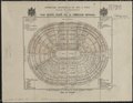 | 4,380 × 3,400 (85.24 MB) | Paris 16 (talk | contribs) | User created page with UploadWizard |
You cannot overwrite this file.
File usage on Commons
The following page uses this file: