File:Extensive floods in Australia.jpg

Original file (5,410 × 3,103 pixels, file size: 7.39 MB, MIME type: image/jpeg)
Captions
Captions
Summary
edit
| Description |
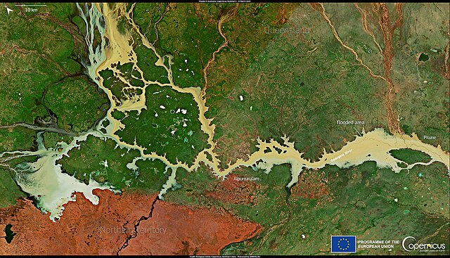
English: This image, acquired on 13 March 2023 by one of the Copernicus Sentinel-2 satellites, shows the flooded areas along the border between Queensland and the Northern Territory, Australia. The gauges along the Georgina River have peaked at 3.5 metres, causing water to flood nearby areas, creating a crisis for graziers and cattle owners. The residents of the town of Urandangi have been evacuated, and some properties remain underwater. The Copernicus Sentinel satellites provide valuable data to identify and delineate the extent of affected areas when a flood occurs and to monitor the consequences of such disastrous events. |
| Date | 15 March 2023 (upload date) |
| Source | Extensive floods in Australia |
| Author | European Union, Copernicus Sentinel-2 imagery |
Licensing
edit

|
This image contains data from a satellite in the Copernicus Programme, such as Sentinel-1, Sentinel-2 or Sentinel-3. Attribution is required when using this image.
Attribution: Contains modified Copernicus Sentinel data 2023
The use of Copernicus Sentinel Data is regulated under EU law (Commission Delegated Regulation (EU) No 1159/2013 and Regulation (EU) No 377/2014). Relevant excerpts:
Free access shall be given to GMES dedicated data [...] made available through GMES dissemination platforms [...].
Access to GMES dedicated data [...] shall be given for the purpose of the following use in so far as it is lawful:
GMES dedicated data [...] may be used worldwide without limitations in time.
GMES dedicated data and GMES service information are provided to users without any express or implied warranty, including as regards quality and suitability for any purpose. |
File history
Click on a date/time to view the file as it appeared at that time.
| Date/Time | Thumbnail | Dimensions | User | Comment | |
|---|---|---|---|---|---|
| current | 12:11, 1 August 2023 | | 5,410 × 3,103 (7.39 MB) | OptimusPrimeBot (talk | contribs) | #Spacemedia - Upload of https://www.copernicus.eu/system/files/2023-03/image_day/20230315_FloodsInAustralia.jpg via Commons:Spacemedia |
You cannot overwrite this file.
File usage on Commons
There are no pages that use this file.