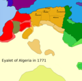
File:Eyalet Algeria in 1771.png

Size of this preview: 743 × 599 pixels. Other resolutions: 298 × 240 pixels | 595 × 480 pixels | 952 × 768 pixels | 1,034 × 834 pixels.
Original file (1,034 × 834 pixels, file size: 65 KB, MIME type: image/png)
File information
Structured data
Captions
Captions
Eyalet Algeria in 1771
إيالة الجزائر
Régence d'Algérie en 1560
Summary edit
| DescriptionEyalet Algeria in 1771.png |
English: Legends:
Français :
English: Sources and Bibliography:
|
| Date | |
| Source | Own work Based on Euratlas Periodis Web - Map of Europe 1800 Southwest. euratlas.net. Retrieved on 2021-06-25. |
| Author | AtlasDzMapper |
Licensing edit
I, the copyright holder of this work, hereby publish it under the following license:
This file is licensed under the Creative Commons Attribution-Share Alike 3.0 Unported license.
- You are free:
- to share – to copy, distribute and transmit the work
- to remix – to adapt the work
- Under the following conditions:
- attribution – You must give appropriate credit, provide a link to the license, and indicate if changes were made. You may do so in any reasonable manner, but not in any way that suggests the licensor endorses you or your use.
- share alike – If you remix, transform, or build upon the material, you must distribute your contributions under the same or compatible license as the original.
File history
Click on a date/time to view the file as it appeared at that time.
| Date/Time | Thumbnail | Dimensions | User | Comment | |
|---|---|---|---|---|---|
| current | 17:03, 22 March 2021 |  | 1,034 × 834 (65 KB) | M.Bitton (talk | contribs) | Reverted to version as of 15:37, 23 December 2019 (UTC): Per COM:OVERWRITE. Revert one more time and you will be reported to the admins |
| 17:02, 22 March 2021 |  | 1,034 × 834 (69 KB) | Mhd240 (talk | contribs) | Reverted to version as of 19:40, 21 March 2021 (UTC) | |
| 16:03, 22 March 2021 |  | 1,034 × 834 (65 KB) | M.Bitton (talk | contribs) | Reverted to version as of 15:37, 23 December 2019 (UTC) | |
| 19:40, 21 March 2021 |  | 1,034 × 834 (69 KB) | Mhd240 (talk | contribs) | Bad map | |
| 15:37, 23 December 2019 |  | 1,034 × 834 (65 KB) | SouthPyrethre (talk | contribs) | Adjust the Dar-El-Sultan province | |
| 20:08, 9 December 2019 |  | 1,034 × 834 (65 KB) | SouthPyrethre (talk | contribs) | Correction of cities locations | |
| 17:40, 8 December 2019 |  | 1,034 × 834 (65 KB) | SouthPyrethre (talk | contribs) | Adjust | |
| 17:39, 8 December 2019 |  | 1,034 × 1,024 (72 KB) | SouthPyrethre (talk | contribs) | Add title. | |
| 17:38, 8 December 2019 |  | 1,034 × 1,024 (64 KB) | SouthPyrethre (talk | contribs) | Adjust Frontier of Beylik according Algerians sources (and historians sources) | |
| 17:36, 8 December 2019 |  | 1,034 × 1,024 (65 KB) | SouthPyrethre (talk | contribs) | Add frontier of Beylik according to Dr. Shaw |
You cannot overwrite this file.
File usage on Commons
There are no pages that use this file.
File usage on other wikis
The following other wikis use this file:
- Usage on ar.wikipedia.org
- Usage on cs.wikipedia.org
- Usage on en.wikipedia.org
- Usage on es.wikipedia.org
- Usage on incubator.wikimedia.org
- Usage on ru.wikipedia.org
Metadata
This file contains additional information such as Exif metadata which may have been added by the digital camera, scanner, or software program used to create or digitize it. If the file has been modified from its original state, some details such as the timestamp may not fully reflect those of the original file. The timestamp is only as accurate as the clock in the camera, and it may be completely wrong.
| PNG file comment |
|
|---|---|
| Horizontal resolution | 28.35 dpc |
| Vertical resolution | 28.35 dpc |
| File change date and time | 15:34, 23 December 2019 |