File:Eyjafjallajökull volcanic ash composite.png

Size of this preview: 600 × 600 pixels. Other resolutions: 240 × 240 pixels | 480 × 480 pixels | 726 × 726 pixels.
Original file (726 × 726 pixels, file size: 95 KB, MIME type: image/png)
Captions
Captions
Add a one-line explanation of what this file represents
| Description |
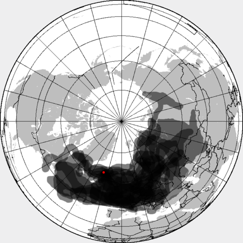
This is a composite map showing the position of the Icelandinc volcanic ash cloud that closed European air space in different days. Based on maps found at http://www.metoffice.gov.uk/aviation/vaac/vaacuk_vag.html Days included:
|
| Date | (UTC) |
| Source | |
| Author |
|
| This is a retouched picture, which means that it has been digitally altered from its original version. Modifications: made all day layers visible. The original can be viewed here: Eyjafjallajökull volcanic ash multilayer.xcf:
|
I, the copyright holder of this work, hereby publish it under the following license:
This file is licensed under the Creative Commons Attribution-Share Alike 3.0 Unported license.
- You are free:
- to share – to copy, distribute and transmit the work
- to remix – to adapt the work
- Under the following conditions:
- attribution – You must give appropriate credit, provide a link to the license, and indicate if changes were made. You may do so in any reasonable manner, but not in any way that suggests the licensor endorses you or your use.
- share alike – If you remix, transform, or build upon the material, you must distribute your contributions under the same or compatible license as the original.
Original upload log edit
This image is a derivative work of the following images:
- File:Eyjafjallajökull_volcanic_ash_multilayer.xcf licensed with Cc-by-sa-3.0
- 2010-04-25T01:29:03Z Cogiati 0x0 (853897 Bytes) added 22 april
- 2010-04-25T01:17:42Z Cogiati 0x0 (845598 Bytes) added 21 april
- 2010-04-25T00:01:51Z Cogiati 0x0 (832938 Bytes) added 19 april
- 2010-04-24T23:20:51Z Cogiati 0x0 (818621 Bytes) added 24 april
- 2010-04-23T21:13:03Z Cogiati 0x0 (814673 Bytes) added 15 april
- 2010-04-23T20:54:25Z Cogiati 0x0 (808456 Bytes) {{Information |Description=This map shows the Icelandic volcanic ash cloud that closed European air space. Every day is shown in a different layer. It's an XCf file editable with GIMP. Based on maps found at http://www.metoff
Uploaded with derivativeFX
File history
Click on a date/time to view the file as it appeared at that time.
| Date/Time | Thumbnail | Dimensions | User | Comment | |
|---|---|---|---|---|---|
| current | 14:53, 27 April 2010 | | 726 × 726 (95 KB) | Cogiati (talk | contribs) | added 17 april |
| 14:09, 26 April 2010 |  | 726 × 726 (93 KB) | Cogiati (talk | contribs) | added 18 april | |
| 07:32, 26 April 2010 |  | 726 × 726 (92 KB) | Cogiati (talk | contribs) | added 25 April | |
| 16:00, 25 April 2010 |  | 726 × 726 (91 KB) | Cogiati (talk | contribs) | added 16 april | |
| 01:56, 25 April 2010 |  | 726 × 726 (90 KB) | Cogiati (talk | contribs) | added 20 april | |
| 01:32, 25 April 2010 |  | 726 × 726 (88 KB) | Cogiati (talk | contribs) | {{Information |Description=This is a composite map showing the position of the Icelandinc volcanic ash cloud that closed European air space in different days. Based on maps found at http://www.metoffice.gov.uk/aviation/vaac/vaacuk_vag.html Days included: |
You cannot overwrite this file.
File usage on Commons
The following page uses this file:
File usage on other wikis
The following other wikis use this file:
- Usage on ca.wikipedia.org
- Usage on da.wikipedia.org
- Usage on de.wikipedia.org
- Usage on en.wikipedia.org
- Usage on es.wikipedia.org
- Usage on eu.wikipedia.org
- Usage on fi.wikipedia.org
- Usage on hu.wikipedia.org
- Usage on it.wikipedia.org
- Usage on ja.wikipedia.org
- Usage on pnb.wikipedia.org
- Usage on pt.wikipedia.org
- Usage on ru.wikipedia.org
- Usage on th.wikipedia.org
- Usage on ur.wikipedia.org
- Usage on vi.wikipedia.org
- Usage on zh.wikipedia.org