File:Eynhallow in 1980.jpg
No higher resolution available.
Eynhallow_in_1980.jpg (640 × 364 pixels, file size: 63 KB, MIME type: image/jpeg)
Captions
Captions
Add a one-line explanation of what this file represents
Summary edit
| Camera location | | View this and other nearby images on: OpenStreetMap |
|---|
| Description |
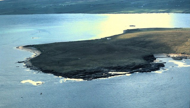
Original description: View of Northwest part of Eynhallow The near coast from Grory (left) to The Grange (right). The rock shelf in the centre is the Fint, with the Robertson House (white) beyond. |
| Date | |
| Source | From geograph.org.uk |
| Author | Stanley Howe |
| Permission (Reusing this file) |
Creative Commons Attribution Share-alike license 2.0 |
Licensing edit

|
This image was taken from the Geograph project collection. See this photograph's page on the Geograph website for the photographer's contact details. The copyright on this image is owned by Stanley Howe and is licensed for reuse under the Creative Commons Attribution-ShareAlike 2.0 license.
|
This file is licensed under the Creative Commons Attribution-Share Alike 2.0 Generic license.
Attribution: Stanley Howe
- You are free:
- to share – to copy, distribute and transmit the work
- to remix – to adapt the work
- Under the following conditions:
- attribution – You must give appropriate credit, provide a link to the license, and indicate if changes were made. You may do so in any reasonable manner, but not in any way that suggests the licensor endorses you or your use.
- share alike – If you remix, transform, or build upon the material, you must distribute your contributions under the same or compatible license as the original.
File history
Click on a date/time to view the file as it appeared at that time.
| Date/Time | Thumbnail | Dimensions | User | Comment | |
|---|---|---|---|---|---|
| current | 20:52, 1 August 2008 | | 640 × 364 (63 KB) | Edward (talk | contribs) | ==Summary== {{Location dec|59.148719|-3.107604|heading:225}} {{Information |Description=w:Eynhallow Original description: '''View of Northwest part of Eynhallow''' The near coast from Grory (left) to The Grange (right). The rock shelf in the centr |
You cannot overwrite this file.
File usage on Commons
The following page uses this file:
File usage on other wikis
The following other wikis use this file:
- Usage on ca.wikipedia.org
- Usage on ceb.wikipedia.org
- Usage on da.wikipedia.org
- Usage on de.wikipedia.org
- Usage on en.wikivoyage.org
- Usage on eu.wikipedia.org
- Usage on hu.wikipedia.org
- Usage on it.wikipedia.org
- Usage on nn.wikipedia.org
- Usage on no.wikipedia.org
- Usage on ru.wikipedia.org
- Usage on www.wikidata.org
- Usage on zh.wikipedia.org