File:Eythrope Pavilion, from the North Bucks Way - geograph.org.uk - 1494830.jpg
No higher resolution available.
Eythrope_Pavilion,_from_the_North_Bucks_Way_-_geograph.org.uk_-_1494830.jpg (640 × 481 pixels, file size: 74 KB, MIME type: image/jpeg)
Captions
Captions
Add a one-line explanation of what this file represents
Summary edit
| Description |
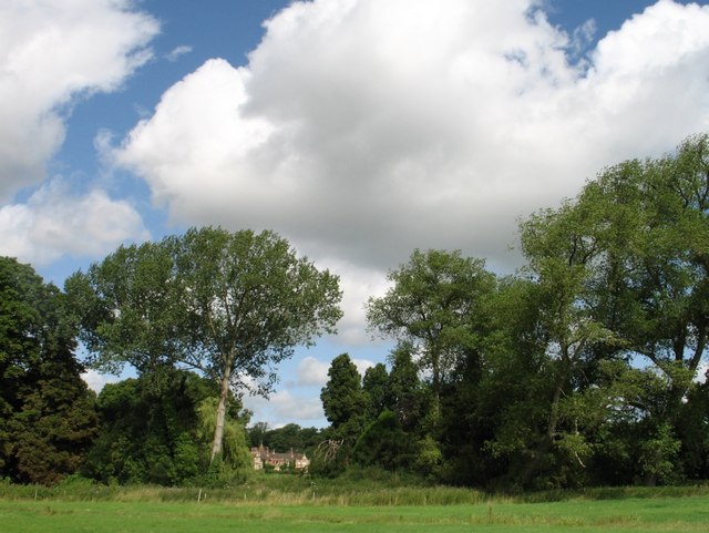
English: Eythrope Pavilion, from the North Bucks Way Eythrope is a hamlet and country house - the Eythrope Pavilion - located to the south east of the village of Waddesdon, Buckinghamshire. The hamlet name is Anglo Saxon in origin, and means "island farm", referring to an island in the River Thame that flows by the hamlet.
This distant view of the Pavilion is all that is visible to the pedestrian from the footpath. The architect of the Eythrope Pavilion was George Devey (18201886), a specialist in lodges, cottages and country mansions, whose distinctive style included the use of tiles and timbers on external walls. A favourite architect of the Rothschild family, he received numerous commissions from family members (as did fellow architect William Huckvale at Tring). The Pavilion was commissioned by Miss Alice Charlotte von Rothschild (1847-1922). When her brother Ferdinand began the construction of Waddesdon Manor in 1874, Miss Rothschild acquired a nearby property at Eythrope where, between 1876 and 1879, she had a park and garden created and Eythrope Pavilion built, near to the River Thame. Because she had suffered from rheumatic fever, she had been advised not to sleep near water because dampness would aggravate her health, so the Pavilion was originally built for daytime occupation only and at nights she returned to Waddesdon Manor. The house was later extended and today looks something of a pot pourri of styles. |
| Date | |
| Source | From geograph.org.uk |
| Author | Ian Petticrew |
| Camera location | | View this and other nearby images on: OpenStreetMap |
|---|
_heading:337.00&language=en)
| Object location | | View this and other nearby images on: OpenStreetMap |
|---|
_heading:337.00&language=en)
Licensing edit

|
This image was taken from the Geograph project collection. See this photograph's page on the Geograph website for the photographer's contact details. The copyright on this image is owned by Ian Petticrew and is licensed for reuse under the Creative Commons Attribution-ShareAlike 2.0 license.
|
This file is licensed under the Creative Commons Attribution-Share Alike 2.0 Generic license.
Attribution: Ian Petticrew
- You are free:
- to share – to copy, distribute and transmit the work
- to remix – to adapt the work
- Under the following conditions:
- attribution – You must give appropriate credit, provide a link to the license, and indicate if changes were made. You may do so in any reasonable manner, but not in any way that suggests the licensor endorses you or your use.
- share alike – If you remix, transform, or build upon the material, you must distribute your contributions under the same or compatible license as the original.
File history
Click on a date/time to view the file as it appeared at that time.
| Date/Time | Thumbnail | Dimensions | User | Comment | |
|---|---|---|---|---|---|
| current | 17:07, 2 March 2011 | | 640 × 481 (74 KB) | GeographBot (talk | contribs) | == {{int:filedesc}} == {{Information |description={{en|1=Eythrope Pavilion, from the North Bucks Way Eythrope is a hamlet and country house - the Eythrope Pavilion - located to the south east of the village of Waddesdon, Buckinghamshire. The hamlet name i |
You cannot overwrite this file.
File usage on Commons
There are no pages that use this file.
File usage on other wikis
The following other wikis use this file:
- Usage on de.wikipedia.org