File:Földrajzi hosszúság meghatározása.gif
No higher resolution available.
Földrajzi_hosszúság_meghatározása.gif (343 × 400 pixels, file size: 56 KB, MIME type: image/gif)
Captions
Captions
Add a one-line explanation of what this file represents
Summary
edit
| Description |
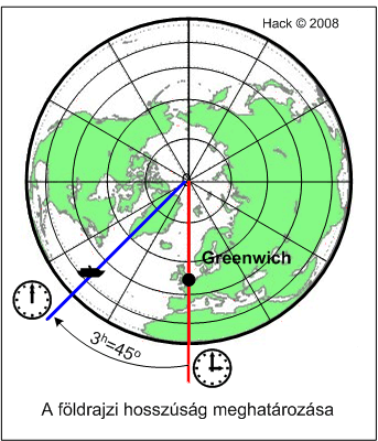
Magyar: Földrajzi hosszúság meghatározása |
| Date | |
| Source | Own work |
| Author | Cike |
Licensing
edit
| I, the copyright holder of this work, release this work into the public domain. This applies worldwide. In some countries this may not be legally possible; if so: I grant anyone the right to use this work for any purpose, without any conditions, unless such conditions are required by law. |
File history
Click on a date/time to view the file as it appeared at that time.
| Date/Time | Thumbnail | Dimensions | User | Comment | |
|---|---|---|---|---|---|
| current | 15:55, 7 July 2008 | | 343 × 400 (56 KB) | Cike (talk | contribs) | {{Információ | leírás = csillagászati helymeghatározás | forrás = sk | dátum = 2008.07.07 | helyszín = Budapest | szerző = Hack Frigyes | engedély = | más változatok = }} |
You cannot overwrite this file.
File usage on Commons
There are no pages that use this file.
File usage on other wikis
The following other wikis use this file:
- Usage on hu.wikipedia.org