File:FFM.png
Size of this preview: 567 × 600 pixels. Other resolutions: 227 × 240 pixels | 454 × 480 pixels | 726 × 768 pixels | 1,228 × 1,299 pixels.
Original file (1,228 × 1,299 pixels, file size: 192 KB, MIME type: image/png)
Captions
Captions
Add a one-line explanation of what this file represents
Summary
edit
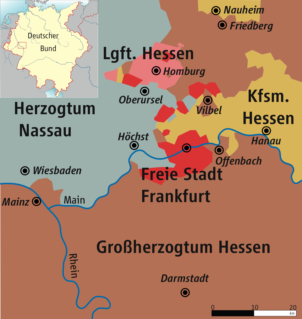
| Description | Karte der Freien Stadt Frankfurt, 1866 / Map of Free City of Frankfurt, 1866 |
| Date | |
| Source | own drawing/Source of Information: Putzger – Historischer Weltatlas, 89. Auflage, 1965 & de: Jean Joseph Tranchot / de: Karl von Müffling |
| Author | kgberger |
| Permission (Reusing this file) |
GNU FDL |

|
This map has been made or improved in the German Kartenwerkstatt (Map Lab). You can propose maps to improve as well.
|
Licensing
edit
I, the copyright holder of this work, hereby publish it under the following licenses:

|
Permission is granted to copy, distribute and/or modify this document under the terms of the GNU Free Documentation License, Version 1.2 or any later version published by the Free Software Foundation; with no Invariant Sections, no Front-Cover Texts, and no Back-Cover Texts. A copy of the license is included in the section entitled GNU Free Documentation License. |
| This file is licensed under the Creative Commons Attribution-Share Alike 3.0 Unported license. | ||
| ||
| This licensing tag was added to this file as part of the GFDL licensing update. |
This file is licensed under the Creative Commons Attribution 2.5 Generic license.
- You are free:
- to share – to copy, distribute and transmit the work
- to remix – to adapt the work
- Under the following conditions:
- attribution – You must give appropriate credit, provide a link to the license, and indicate if changes were made. You may do so in any reasonable manner, but not in any way that suggests the licensor endorses you or your use.
You may select the license of your choice.

|
File:Freie Stadt Frankfurt.svg is a vector version of this file. It should be used in place of this PNG file.
File:FFM.png → File:Freie Stadt Frankfurt.svg
For more information, see Help:SVG. |
 |
File history
Click on a date/time to view the file as it appeared at that time.
| Date/Time | Thumbnail | Dimensions | User | Comment | |
|---|---|---|---|---|---|
| current | 10:52, 31 March 2009 | | 1,228 × 1,299 (192 KB) | Ziegelbrenner (talk | contribs) | 2009-03-31 |
| 12:15, 8 October 2007 |  | 1,228 × 1,299 (154 KB) | Ziegelbrenner (talk | contribs) | ||
| 11:58, 30 August 2007 |  | 1,226 × 1,313 (102 KB) | Ziegelbrenner (talk | contribs) | ||
| 13:08, 27 August 2007 |  | 1,223 × 1,276 (338 KB) | Ziegelbrenner (talk | contribs) | == Beschreibung == {{Information |Description=Karte der Freien Stadt Frankfurt, 1866 / Map of Freie Stadt Frankfurt, 1866 |Source=own drawing/Source of Information: Putzger – Historischer Weltatlas, 89. Auflage, 1965 & de: Jean Joseph Tranchot / [[ |
You cannot overwrite this file.
File usage on Commons
There are no pages that use this file.
File usage on other wikis
The following other wikis use this file:
- Usage on de.wikipedia.org
- Usage on eo.wikipedia.org
- Usage on fr.wikipedia.org
- Usage on nl.wikipedia.org
- Usage on no.wikipedia.org
- Usage on pl.wikipedia.org