File:FF 68 Strecke.jpg

Size of this preview: 743 × 600 pixels. Other resolutions: 298 × 240 pixels | 595 × 480 pixels | 751 × 606 pixels.
Original file (751 × 606 pixels, file size: 82 KB, MIME type: image/jpeg)
Captions
Captions
Add a one-line explanation of what this file represents
Summary
edit
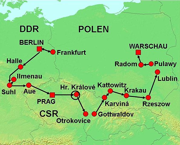
| Description | Internationale Friedensfahrt 1968, Streckenverlauf |
| Date | (UTC) |
| Source |
This file was derived from: Topographic30deg N30E0.png:  |
| Author |
| This is a retouched picture, which means that it has been digitally altered from its original version. Modifications: Ausschnitt Mitteleuropa, Grenzen. The original can be viewed here: Topographic30deg N30E0.png:
|
Licensing
edit
I, the copyright holder of this work, hereby publish it under the following licenses:
| This file is licensed under the Creative Commons Attribution-Share Alike 3.0 Unported license. | ||
| ||
| This licensing tag was added to this file as part of the GFDL licensing update. |

|
Permission is granted to copy, distribute and/or modify this document under the terms of the GNU Free Documentation License, Version 1.2 or any later version published by the Free Software Foundation; with no Invariant Sections, no Front-Cover Texts, and no Back-Cover Texts. A copy of the license is included in the section entitled GNU Free Documentation License. |
You may select the license of your choice.
Original upload log
edit
This image is a derivative work of the following images:
- File:Topographic30deg_N30E0.png licensed with Cc-by-sa-3.0-migrated, GFDL
- 2005-05-26T17:22:31Z Koba-chan 1800x1800 (1149560 Bytes) ---- Map created from [http://www2.demis.nl/mapserver/mapper.asp DEMIS Mapserver], which are public domain. [[User:Koba-chan|Koba-chan]] {{GFDL}} [[Category:Topographic maps]] [[Category:Earth]]
Uploaded with derivativeFX
File history
Click on a date/time to view the file as it appeared at that time.
| Date/Time | Thumbnail | Dimensions | User | Comment | |
|---|---|---|---|---|---|
| current | 09:57, 6 January 2013 | | 751 × 606 (82 KB) | Greifen (talk | contribs) | == {{int:filedesc}} == {{Information |Description=Internationale Friedensfahrt 1968, Streckenverlauf |Source={{Derived from|Topographic30deg_N30E0.png|display=50}} |Date=2013-01-06 09:54 (UTC) |Author=*File:Topographic30deg_N30E0.png: [[User:Koba... |
You cannot overwrite this file.
File usage on Commons
There are no pages that use this file.
File usage on other wikis
The following other wikis use this file:
- Usage on de.wikipedia.org