File:FRONT VIEW OF OLD SLAVE HOUSE - Strawberry Hill Plantation, U.S. Route 43, Forkland, Greene County, AL HABS ALA,32-FORK.V,2-10.tif

Size of this JPG preview of this TIF file: 800 × 582 pixels. Other resolutions: 320 × 233 pixels | 640 × 465 pixels | 1,024 × 744 pixels | 1,280 × 931 pixels | 2,560 × 1,861 pixels | 5,000 × 3,635 pixels.
Original file (5,000 × 3,635 pixels, file size: 17.34 MB, MIME type: image/tiff)
Captions
Captions
Add a one-line explanation of what this file represents
Summary edit
| Historic American Buildings Survey Alex Bush, Photographer, November 9, 1936 FRONT VIEW OF OLD SLAVE HOUSE - Strawberry Hill Plantation, U.S. Route 43, Forkland, Greene County, AL | ||||
|---|---|---|---|---|
| Photographer |
Related names:
|
|||
| Title |
Historic American Buildings Survey Alex Bush, Photographer, November 9, 1936 FRONT VIEW OF OLD SLAVE HOUSE - Strawberry Hill Plantation, U.S. Route 43, Forkland, Greene County, AL |
|||
| Depicted place | Alabama; Greene County; Forkland | |||
| Date | Documentation compiled after 1933 | |||
| Medium | 5 x 7 in. | |||
| Current location |
Library of Congress Prints and Photographs Division Washington, D.C. 20540 USA http://hdl.loc.gov/loc.pnp/pp.print |
|||
| Accession number |
HABS ALA,32-FORK.V,2-10 |
|||
| Credit line |
|
|||
| Notes |
|
|||
| Source | https://www.loc.gov/pictures/item/al0202.photos.002475p | |||
| Permission (Reusing this file) |
|
|||

| Object location | | View this and other nearby images on: OpenStreetMap |
|---|
File history
Click on a date/time to view the file as it appeared at that time.
| Date/Time | Thumbnail | Dimensions | User | Comment | |
|---|---|---|---|---|---|
| current | 01:28, 28 June 2014 | 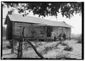 | 5,000 × 3,635 (17.34 MB) | Fæ (talk | contribs) | GWToolset: Creating mediafile for Fæ. HABS batch upload restart 26 June 2014 (p21:101)x |
You cannot overwrite this file.
File usage on Commons
The following page uses this file:
File usage on other wikis
The following other wikis use this file:
- Usage on en.wikipedia.org
- Usage on fa.wikipedia.org
- Usage on ko.wikipedia.org