File:FR 17 Saint-Vaize et Bussac-sur-Charente - Rochefollet.JPG

Size of this preview: 800 × 450 pixels. Other resolutions: 320 × 180 pixels | 640 × 360 pixels | 1,024 × 576 pixels | 1,280 × 720 pixels | 2,560 × 1,440 pixels | 4,608 × 2,592 pixels.
Original file (4,608 × 2,592 pixels, file size: 2.79 MB, MIME type: image/jpeg)
Captions
Captions
Add a one-line explanation of what this file represents
Summary edit
| Description |
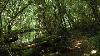
Français : Le Rochefollet est un petit cours d'eau de Charente-Maritime, affluent de la Charente, qui prend sa source dans la commune du Douhet, puis sépare les communes de Saint-Vaize (rive droite, à gauche sur l'image) et de Bussac-sur-Charente (rive gauche, à droite sur l'image), avant de se jeter par la rive droite dans la Charente. Un sentier, emprunté par quelques promeneurs, longe ce ruisseau. |
| Date | |
| Source | Own work |
| Author | KiwiNeko14 |
| Object location | | View this and other nearby images on: OpenStreetMap |
|---|
Licensing edit
I, the copyright holder of this work, hereby publish it under the following license:
This file is licensed under the Creative Commons Attribution-Share Alike 4.0 International license.
- You are free:
- to share – to copy, distribute and transmit the work
- to remix – to adapt the work
- Under the following conditions:
- attribution – You must give appropriate credit, provide a link to the license, and indicate if changes were made. You may do so in any reasonable manner, but not in any way that suggests the licensor endorses you or your use.
- share alike – If you remix, transform, or build upon the material, you must distribute your contributions under the same or compatible license as the original.
File history
Click on a date/time to view the file as it appeared at that time.
| Date/Time | Thumbnail | Dimensions | User | Comment | |
|---|---|---|---|---|---|
| current | 17:43, 1 January 2016 | | 4,608 × 2,592 (2.79 MB) | KiwiNeko14 (talk | contribs) | User created page with UploadWizard |
You cannot overwrite this file.
File usage on Commons
The following page uses this file: